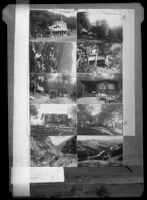
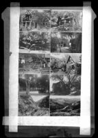
Ten postcards views including: one view of the main Outside Inn building, six views of cabins at the Outside Inn, one aerial view of Topanga Canyon including the Outside Inn property, and two views of the road wending through Topanga Canyon
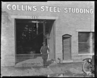
View towards a large open double-doorway of the brick building housing the Collins Steel Studding. A man holding a structure with long metal rods is standing at the doorway. On the wall above the door the name of the business is painted as well as the address "685". The front corner of a care is visible on the right
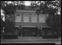
Exterior view of the former Elks Temple, or Lodge, located at the southeast corner of Main St. and Pier Ave. in Santa Monica. The letters "BPOE" along the cornice of each visible side of the building stand for: Benevolent and Protective Order of Elks. The BPOE is an American fraternal order and social club founded in 1868.
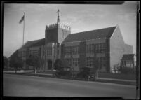
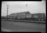
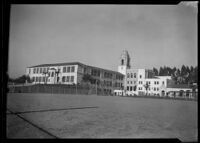
Exterior view of Madison School, a brick and stone building with a crenellated tower surmounted by a weathervane. the school was located at 1020 Arizona Ave.
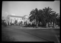
The Santa Monica Bay Woman's Club building was completed in 1914 and is located at 1210 Fourth Street since 1914.The architect of the clubhouse was Henry C. Hollwedel.
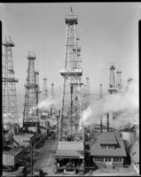
View of the Venice oil field, a landscape of derricks, with steam pipes and buildings made of wood and corrugated metal at their bases, with the beach on the far left. The foreground center building has signs reading "Flynn Bros." and "No Smoking, Keep Out." Signs on the derricks read "Bergman Albright No. 3," "Pan Gulf Pet. Co. LTD, Hattie Weber Mabel [..]orner, Well No [...]," "S.L.R. Pet. Prop's LTD., J. T. Russell No. 1," "Pan Gulf Petroleum Co. Ltd., Venice No. 1," "[...] Powell-Stockton, W. G. Davis No. 1," and "Know Powell Stockton, W. G. Davis No. 4."
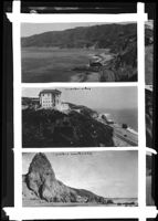
Upper photo: view of the Pacific Coast Highway looking west towards a lighthouse. The road runs along the shore at right between the calm ocean at left and the steep cliffs at right. The lighthouse consists of a long rectangular building with a tall tower at left. The Santa Monica Mountains are visible in the background.
Exterior view of the mortuary with three palm trees on 7th street. A sign on the street curb reads: 7th street. A sign above a window reads: memorial chapel. The Santa Monica location of Todd and Leslie listed in some online obituary notices is 1307 7th street.
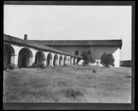
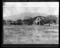
Exterior view of San Miguel Arcangel from the southeast, showing an arcade supporting a tile roof (left) and the church (right). Over one of the arches is written "San Miguel Mission" and "1797." A bell suspended from a wooden frame is visible in front of the church wall (right).
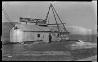
Man in suit and smoking a cigar stands in front of the La Vina Mutual Water Co. pumping plant, a building constructed of corrugated metal, as water pours out of a pipe that extends out from the building. Mountains with snow are visible in the background
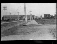
View facing east down fifth street toward the Southern Pacific Arcade Depot. A Blue Line streetcar is visible near the Depot far down the street. Utility poles line the dirt street and tracks on both sides. In the background, a building at right has a sign on it reading "Narcisse House". The Depot building dominates the background at left.
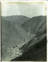
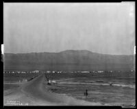
View down a dirt road towards the town of Avenal which appears as a narrow band of buildings and power poles along the main road through town, with the Santa Lucia mountain range in the background. The buildings appear to be mostly houses, a few businesses and a church on the far right. There is also an oil rig on the center-right side of town. Legible signage in the photograph includes: Golden Rule Shoe Shop, The Republic Supply Co. of California, and H. C. Smith MFG Co.
The Mission of San Antonio de Padua is located in the valley of the San Antonio River along the Santa Lucia Mountains. From 1893, after the roof tiles were removed, there was no roof over the church or the arcade walkway until a 1903-1908 restoration. The photograph shows the arcade with no roof and a wooden roof over the church and may therefore show the church during the restoration
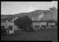
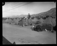
Kneen’s Kamp, built by Thomas W. (Bill) Kneen in 1916, was a resort located on Topanga Canyon Boulevard near Robinson Road. The camp operated until the mid- 1920's.
The St. Francis Dam was a 200-foot high concrete gravity-arch dam built between 1924 and 1926 in St. Francisquito Canyon (near present-day Castaic and Santa Clarita). The dam collapsed on March 12, 1928 at two and a half minutes before midnight. The resulting flood killed more than 600 residents plus an unknown number of itinerant farm workers camped in San Francisquito Canyon, making it the 2nd greatest loss of life in California after the 1906 San Francisco earthquake. It is considered the worst American civil engineering failure in the 20th century.
Hayward Thompson successfully drove for five hours and thirteen minutes, a total of 100 miles, through congested traffic all while completely blindfolded. The affair was his 333rd exhibition and the longest since his sixty mile drive in Miami.
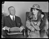
W. H. Bowers and Olive Orr Brugen-Schmidt Bowers, married three just months, seated together at a court proceeding. Olive Bowers was accused of plotting with Elmer M. Archer to poison her husband. The plot was discovered when their conversations were overheard on a 2-party telephone line.
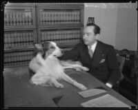
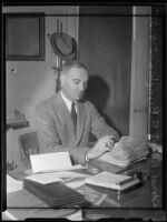
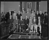
Irvin Taplin, seated, and L.E. Lampton, standing, both with right hands raised, with Harry Hunt, standing, looking on, at desk with pens, papers, books, and sign reading TAPLIN
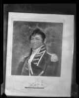
Painting of King Gustav V, in military uniform with sword, printed as a plate in a book and photographed from open book on mat or carpet. Caption under plate reads: H. M. King Gustaf V of Sweden (In the Swedish Chamber of Commerce of the U.S.A.)
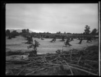
View of plant debris and a muddy agricultural field with evenly spaced plantings beyond in the path of the flood caused by the failure of the Saint Francis Dam. A straight, elevated area in the background may be a road.
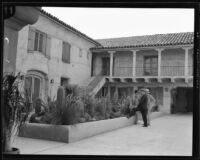
Three men stand in Harry Chandler's Baja California ranch, the California-Mexico Land and Cattle Company (C & M Ranch). The courtyard's landscaping includes a variety of desert plants.
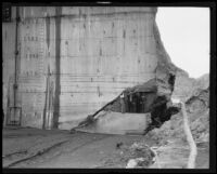
The St. Francis Dam was a 200-foot high concrete gravity-arch dam built between 1924 and 1926 in St. Francisquito Canyon (near present-day Castaic and Santa Clarita). The dam collapsed on March 12, 1928 at two and a half minutes before midnight. The resulting flood killed more than 600 residents plus an unknown number of itinerant farm workers camped in San Francisquito Canyon, making it the 2nd greatest loss of life in California after the 1906 San Francisco earthquake. It is considered the worst American civil engineering failure in the 20th century.
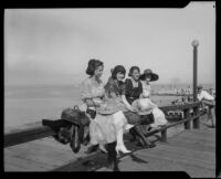
Photograph of four young women seated on a pier railing opposite the entrance to a dance hall (not visible in this photo, see image ark no. 21198/zz002d9zdt). A young man watches from the background.
The St. Francis Dam was a 200-foot high concrete gravity-arch dam built between 1924 and 1926 in St. Francisquito Canyon (near present-day Castaic and Santa Clarita). The dam collapsed on March 12, 1928 at two and a half minutes before midnight. The resulting flood killed more than 600 residents plus an unknown number of itinerant farm workers camped in San Francisquito Canyon, making it the 2nd greatest loss of life in California after the 1906 San Francisco earthquake. It is considered the worst American civil engineering failure in the 20th century.
View of what appears to be a fallen bridge with wooden railings over the Los Angeles River during or after a violent rain storm. A group of men wearing high boots is next to the bridge.
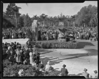
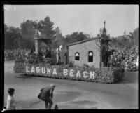
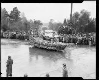
The "Treasure Ship" float with a Spanish galleon bearing golden gifts; the intended inhabitants of the float were driven away by the rain. The Pasadena Memorial Flagpole (Goodhue Flagpole) is visible behind the float in its original location in the middle of the intersection of Orange Grove and Colorado Boulevard. The float was entered by the Hotel Vista del Arroyo.
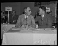
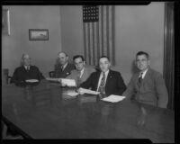
![Judge Irvin Taplin, Deputy District Attorney Harry Hunt, and County Clerk L.E. Lampton, at Taplin's desk, [1929?]](https://iiif.library.ucla.edu/iiif/2/ark%3A%2F21198%2Fzz002cndj7/full/!200,200/0/default.jpg)
![Painting of King Gustav V of Sweden by Pierre Tartoue, photographed from book, [1933?]](https://iiif.library.ucla.edu/iiif/2/ark%3A%2F21198%2Fzz002cngcm/full/!200,200/0/default.jpg)
![Fallen bridge over the Los Angeles River [?], [Los Angeles?], 1927](https://iiif.library.ucla.edu/iiif/2/ark%3A%2F21198%2Fzz002ddfbw/full/!200,200/0/default.jpg)
![Commercial street flooded during or after a rainstorm, [Los Angeles County?], 1927](https://iiif.library.ucla.edu/iiif/2/ark%3A%2F21198%2Fzz002ddfj0/full/!200,200/0/default.jpg)