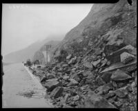
Possibly related to the article “Motoring : Coast Highway to Be Improved, Preparations Being Made to Handle Millions, Work Now Under Way Between Two Beach Cities, Right of Way of 100 Feet in Communities Planned.” Los Angeles Times, 9 Feb. 1930.
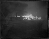
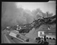
View towards Pacific Palisades fire from the Pacific Coast Highway and Porto Marina Way, with Thelma Todds Cafe on the right. Black and gray smoke fills the sky beyond the structures of the hills covered in trees. One truck drives towards the smoke, and on the other side of the road a steady stream of traffic is driving the opposite direction.
2-story house with Spanish tile roof, with boards against side of house, with patio, steps, and planters in foreground, with cliff, highway, and ocean at left. The edge of the patio pavement is rough as though it broke off in a landslide down the cliff.
2-story house with Spanish tile roof, with boards, chains, and pulleys on patio and against side of house, with overhanging trees, with hills and ocean in left background. In another image of this house the edge of the patio pavement on the cliff side is ragged as though lost in a landslide (uclamss_1429_0435).
Castle Rock beach, nestled between Topanga canyon and the Pacific Ocean, was affected by the Topanga Canyon and Malibu fires as they swept toward the sea.
![Pacific Coast Highway, [Orange County?], [1930 or 1931?]](https://iiif.library.ucla.edu/iiif/2/ark%3A%2F21198%2Fzz002d9qh0/full/!200,200/0/default.jpg)
![House overlooking Roosevelt Highway, damaged (or under construction), [Malibu?], circa 1929-1939](https://iiif.library.ucla.edu/iiif/2/ark%3A%2F21198%2Fzz002d9q49/full/!200,200/0/default.jpg)
![House overlooking Roosevelt Highway, damaged (or under construction), [Malibu?], circa 1929-1939](https://iiif.library.ucla.edu/iiif/2/ark%3A%2F21198%2Fzz002d9pxq/full/!200,200/0/default.jpg)