Study of development for Santa Monica Boulevard Parkway, Beverly Hills, 1930
Item Overview
- Title
- Study of development for Santa Monica Boulevard Parkway, Beverly Hills, 1930
- Alternative title
- Santa Monica Blvd. Parkway
- Date Created
- [August 1930]
- Date
- 1930-08
- Language
- English
- Collection
- Ralph D. Cornell Papers, 1925-1972
Notes
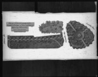
- Description
- Roadside zones like this one were developed in 1930 to separate the residential district from the Boulevard. They included pedestrian paths, gardens and fountains. Plan includes an aerial view of the zone and a perspective sketch of the fountain.
- Caption
-
Labels on plan: Sierra Dr., Carmelita Ave., Carmelita Place
Study of Development for Santa Monica Blvd. parkway; Beverly Hills, Calif., Cook-Hall & Cornell, Landscape Archts & City Planners, 3723 Wilshire Blvd. L.A.
Physical Description
- Extent
- 1 photographic negative
- Dimensions
- 8 x 10 inches
Keywords
- Genre
-
black-and-white photographs
cellulose nitrate film
landscaping plans - Location
- California--Beverly Hills
- Longitude
- 34.08090424344256
- Latitude
- -118.39064598083496
- Resource type
- still image
- Subjects
-
boulevards
Business
fountains
Transportation
gardens
roadside improvement
Government
Santa Monica Boulevard (Beverly Hills, Calif.)
paths - landscape architecture
Find This Item
- Repository
- University of California, Los Angeles. Library Special Collections
- Local Identifier
-
61
uclamss_1411_0061 - ARK
- ark:/21198/zz002b5xc6
- Manifest url
-

Access Condition
- Rights statement
- copyrighted
- Funding Note
- Access to this collection is generously supported by Arcadia funds.