Development plan for Twentynine Palms
Item Overview
- Title
- Development plan for Twentynine Palms
- Alternative title
- 29 Palms California development plan
- Date Created
- [between 1924 and 1933]
- Date
- 1924/1933
- Language
- English
- Collection
- Ralph D. Cornell Papers, 1925-1972
Notes
- Description
-
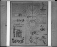
Faded words behind 29 Palms California title read: Village; San Bernardino County, California.
Bottom right corner has a "Key Map of 29 Palms Village and Vicinity" of the San Bernardino area. Plan also has small sketches of a cabin in the desert and "The Dancing Joshua"
City name is Twentynine Palms, also 29 Palms and previously, Twenty-Nine Palms - Caption
-
29 Palms Corporation Ltd. Owners & Developers; Cook-Hall & Cornell, Landscape Architects; C. G. Fitz Gerald & Associates Engineers; 580-14.
Labels on plan: Glendale, Los Angeles, Pasadena, Anaheim, Long Beach, Pacific Ocean, San Juan Capistrano, To San Diego, Ontario, Colton, Riverside, Beaumont, Perris, Banning, Redlands, San Bernardino, Cajon, Victorville, Barstow, Daggett, Ludlow, Bagdad, Amboy, To Needles, Palm Springs, Whitewater, Inspiration Pt., Morongo, Joshua Trees, To Phoenix, To El Paso, Salton Sea, Mecca, Indio
29 Palms California. Being a community development. Planned to provide winter homes and hotel accommodations in a unique and picturesque setting, where horseback riding, desert trails and outdoor sports offer recreation in happy contrast to city life.
Physical Description
- Extent
- 1 photographic print
- Dimensions
- 8 x 10 inches
Keywords
- Genre
-
black-and-white photographs
landscaping plans - Location
- California--Twentynine Palms
- Longitude
- 34.1355582
- Latitude
- -116.0541689
- Resource type
- still image
- Subjects
-
Environment
Business
land use
urban planning
Government
Twentynine Palms (Calif.) - landscape architecture
Find This Item
- Repository
- University of California, Los Angeles. Library Special Collections
- Local Identifier
- uclamss_1411_0046
- ARK
- ark:/21198/zz002b5wvz
- Manifest url
-

Access Condition
- Rights statement
- copyrighted
- Funding Note
- Access to this collection is generously supported by Arcadia funds.