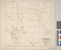
Map of Central California from 37th to 40th deg. north lat. : showing various railroad routes projected or in progress together with a practicable route to enter the state with a Pacific railroad Description: Digitization took place as part of the California Cultures Project. Date: 1860 Resource Type: still image Collection: Maps of Los Angeles, California, the United States and the World, circa 1516-1970
Commissioners official railway map of California, completed to January 1st, 1900 Description: Scale not given Date: circa 1900 Resource Type: still image Collection: Maps of Los Angeles, California, the United States and the World, circa 1516-1970