Using Digital Collections Content
About
Give Us Feedback
Search in
search for
Search
All Fields
Title
Subject
Search
Browse items
Subject
England--Maps--Early works to 1800
4
Early maps--Facsimiles
2
Early maps
1
England--Maps
1
England--Maps--History
1
more
Subject
»
Resource Type
cartographic
4
Genre
map
4
Location
England
2
Ireland
1
London (England)
1
Scotland
1
Wiltshire (England)
1
Date
Date range begin
–
Date range end
Current results range from
1593
to
1961
View distribution
Language
Latin
4
English
2
Collection
Henry J. Bruman Map Collection
4
Repository
University of California, Los Angeles. Library. Henry J. Bruman Map Collection
4
Search Constraints
You searched for:
Subject
England--Maps--Early works to 1800
✖
Remove constraint Subject: England--Maps--Early works to 1800
Start Over
4
Catalog Results
Sort by Relevance
Relevance
Title (A-Z)
Title (Z-A)
Date (newest)
Date (oldest)
Number of results to display per page
10 per page
10
per page
20
per page
50
per page
100
per page
View results as:
List
Created with Sketch.
List View
List
Gallery
Created with Sketch.
Gallery View
Gallery
Search Results
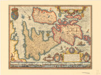
Angliae, Scotiae, et Hiberniae, Sive Britannicar: insularum Descriptio.
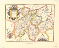
Saxton’s map of Northhamptonshire, Bedfordshire, Cambridgeshire, Huntingdonshire and Rutland, 1576
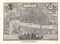
Londinvm Feracissimi an: Gliae Regni Metropolois
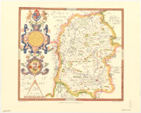
Saxton’s map of Wiltshire, 1576