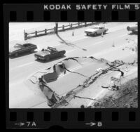
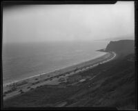
Possibly related to the article “Motoring : Coast Highway to Be Improved, Preparations Being Made to Handle Millions, Work Now Under Way Between Two Beach Cities, Right of Way of 100 Feet in Communities Planned.” Los Angeles Times, 9 Feb. 1930.
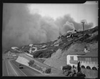
View towards Pacific Palisades fire from the Pacific Coast Highway and Porto Marina Way, with Thelma Todds Cafe on the right. Black and gray smoke fills the sky beyond the structures of the hills covered in trees. One truck drives towards the smoke, and on the other side of the road a steady stream of traffic is driving the opposite direction.
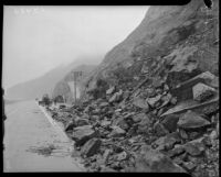
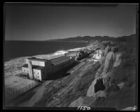
2-story house with Spanish tile roof, with boards against side of house, with patio, steps, and planters in foreground, with cliff, highway, and ocean at left. The edge of the patio pavement is rough as though it broke off in a landslide down the cliff.
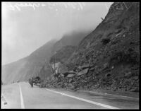
2-story house with Spanish tile roof, with boards, chains, and pulleys on patio and against side of house, with overhanging trees, with hills and ocean in left background. In another image of this house the edge of the patio pavement on the cliff side is ragged as though lost in a landslide (uclamss_1429_0435).
Castle Rock beach, nestled between Topanga canyon and the Pacific Ocean, was affected by the Topanga Canyon and Malibu fires as they swept toward the sea.
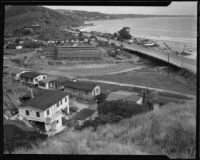
View of Bay Shore Camp in distance, with cabins and larger buildings in the distance, Coca-Cola sign and other signs, with bridges on both sides, another building at right, and Pacific Coast Highway and parked car prominent in foreground, under cloudy sky
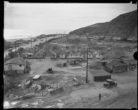
Possibly related to the article “Motoring : Coast Highway to Be Improved, Preparations Being Made to Handle Millions, Work Now Under Way Between Two Beach Cities, Right of Way of 100 Feet in Communities Planned.” Los Angeles Times, 9 Feb. 1930.
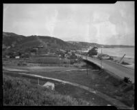
Bird's-eye view of Roosevelt Highway (Pacific Coast Highway), including the present bridge over Topanga Creek and the new bridge under constructin in the center beyond two rows of small cabins. Houses, cars, about 3 people, and construction debris in foreground, Coca-Cola sign in left middleground on the "De Long" cafe, cars on highway, ocean and hills in background. A sign on the highway next to the cabins reads: "Topanga Beach Auto Camp."
This photograph appears with the article, "Waste of Road Funds Charged: Roosevelt Highway Link's Rebuilding Scored; D. O. Brant Declares Project Needless Expenditure; Erection of New Bridge Also Shares in Criticism." Los Angeles Times, 5 Feb. 1933: 14.
Bird's-eye view of Roosevelt Highway (Pacific coast Highway), including the bridge over Topanga Creek, with hills, houses, and construction of new bridge underway at left, "De Long" cafe with Coca-Cola sign at right, cars on highway, crane at right, ocean and hills in background. Beyond the creek bed is a long row of small vacation cabins with a sign reading "Cabins" next to the cabin on the highway.
Caption for a similar photograph for the article reads: Picture shows present Roosevelt Highway bridge across Topanga Creek at right with the new bridge under construction in the middle background, the view being across the lagoon area to be filled.
House with Spanish tile roof, with boards, chains, and pulleys on patio and against side of house, with overhanging tree at right and ocean at left. In another image of this house the edge of the patio pavement on the cliff side is ragged as though lost in a landslide (uclamss_1429_0435).
Possibly related to the article “Motoring : Coast Highway to Be Improved, Preparations Being Made to Handle Millions, Work Now Under Way Between Two Beach Cities, Right of Way of 100 Feet in Communities Planned.” Los Angeles Times, 9 Feb. 1930.
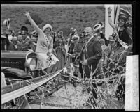
Miss Canada, Grant Donley, in skirt, sweater, and knitted hat, and Miss Mexico, Marianita Servin, in skirt, sleeveless blouse, and necklace, lighting explosive fuse to open Roosevelt Highway, with cut ribbons on ground, wide ribbon behind them, and uniformed officers and crowd, many waving hats, and hillside in background
View of the Roosevelt Highway along the California coastline near Santa Monica Bay. Marion Davies' Estate appears to be the prominent white building in the top left of the photo. The Santa Monica Pier also appears to be in the far background.
Patio overlooking Roosevelt Highway, with man in coat standing at corner looking down, with cliff, highway, and ocean at left, hills and cloudy sky in background. The edge of the patio pavement is rough as though it broke off in a landslide down the cliff.
C.C. Young, at center, in suit and tie, holding knife, smiling, with Grant Donley, in skirt, sweater, knitted hat, and Miss Canada sash, waving, seated on car at left, and Marianita Servin (daughter of Dr. Guillermo Servin), in skirt, sleeveless blouse, necklace, and Miss Mexico sash, waving, at right, with tangle of paper ribbons in foreground, uniformed officers and crowd, many waving hats, and hillside in background
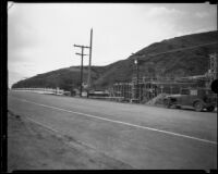
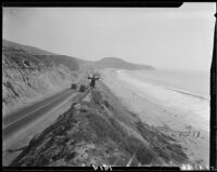
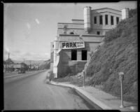
Section of Pacific Coast Highway with steep descending embankment under construction at right, hills at left, trucks at center, cars in background, building with round tower in right background. Sign in right background reads: This property to be subdivided, near future. For information apply Burton & Co., Realtors, or T.C. Hitchings, Realtor, 3576 Wilshire Blvd., FItzroy 1261, Los Angeles
Bird’s-eye view of Bay Shore Camp, with main building and gas pumps at center, cabins at right, cars, bicycle, and mules, with pier, bay, boats, and bridge in background, Pacific Coast Highway, cars, and hillside in foreground
Caption for a similar photograph for the article reads: Picture shows present Roosevelt Highway bridge across Topanga Creek at right with the new bridge under construction in the middle background, the view being across the lagoon area to be filled.
Possibly related to the article “Irvine Company Asks Permit for Dredging.” Los Angeles Times, 19 Oct. 1931. The article states: The Irvine Company ... has filed an application ... to fill in a large portion of tidelands ... This will provide anchorage for many more yachts near Bay Shore Camp and will open a larger channel to Upper Newport Bay.
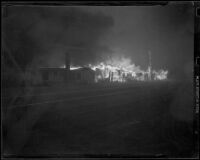
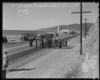
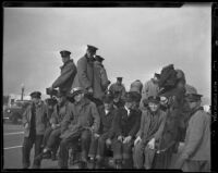
A group of about twenty firefighters rest on a truck bed after battling flames along California Highway 1 (the Roosevelt Highway, or Pacific Coast Highway).
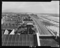
Bird's eye view facing south towards the Pacific Coast Highway on the section between Long Beach and Huntington Beach. The highway divides the housing tracts (left) from the beach (right) with a pier in the distance.
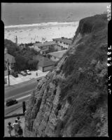
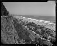
View from Palisades Park cliff of Santa Monica shoreline, with cliff in right foreground, street railroad tracks and Pacific Coast Highway in midground, buildings and beach in background
Southern exterior view of the Sorrento Beach Club against the Palisades cliffs, facing northwest from Pacific Coast Highway. A restaurant, other buildings and cars are visible on the highway. The restaurant bares a sign reading "Ne--'s Grill".
Bird's-eye view of Marion Davies residence and Santa Monica shoreline, with cliffs in left foreground, Pacific Coast Highway in midground, beach, ocean and Santa Monica Pier in background
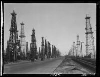
View along Pacific Coast Highway, with about 40 oil well drilling rigs visible on both sides of highway, with automobiles, palm trees, kiosk, and lampposts, with railroad tracks and ocean at right; sign on 1 rig in foreground reads (reversed): Pacific Coa[st] Oil Co.
Bird's-eye view towards Santa Monica Canyon where Chautauqua Blvd. and West Channel Road end at Pacific Coast Highway on the coast, with the ocean and the Pacific Palisades cliffs beyond. The canyon area has buildings and open land and there are two houses on the beach. A sign at the top of the cliff reads: "This is Huntington Palisades." A sign on a building on West Channel Road reads: "Law's Pharmacy."
View along Pacific Coast Highway, with about 90 oil well drilling rigs visible on both sides of highway, area without rigs in foreground, with automobiles, palm trees, and power poles, with railroad tracks and ocean at left
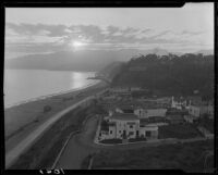
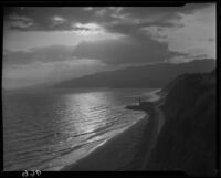
Bird's-eye view from cliff at sunset of building with lighthouse tower, Pacific Coast Highway with cars, and Santa Monica Bay, with sun through clouds in background
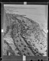
Bird's-eye view of Santa Monica Bay, with many boats, with Santa Monica Pier with crowd in foreground, crowded beach, Pacific Coast Highway, Deauville Club, Santa Monica Athletic Club, Windermere Hotel, and Palisades Park cliffs in background
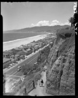
Bird's-eye view from Palisades Park towards Santa Monica Beach facing northwest. Four people (two women in view, two farther ahead) walk down the Idaho path at right. A portion of the refurbished Palisades Park wooden rail fence is viewed atop the cliff. Beach homes line Pacific Coast Highway at left.
Bird's-eye view from Palisades Park towards Santa Monica Beach, seen from the cliffs above the Idaho foot path(traversed by for females, a fifth partially in view). The path leads to Pacific Coast Highway, beach houses, and the beach.
Exterior view of the Sorrento Beach Club against the Palisades cliffs, facing northeast from Pacific Coast Highway. A pedestrian and cars are visible on highway.
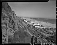
Bird's-eye view of the Pacific Coast Highway at the base of the California Incline with Santa Monica Beach and pier beyond. View taken from Palisades Park, with the cliff visible on the left.
Bird's-eye view from Palisades Park (the area between Alta Ave. and Palisades Ave.) towards beach houses along Pacific Coast Highway (addresses between 704 and 609) and Santa Monica Beach below.
![Pacific Coast Highway, [Orange County?], [1930 or 1931?]](https://iiif.library.ucla.edu/iiif/2/ark%3A%2F21198%2Fzz002d9qh0/full/!200,200/0/default.jpg)
![House overlooking Roosevelt Highway, damaged (or under construction), [Malibu?], circa 1929-1939](https://iiif.library.ucla.edu/iiif/2/ark%3A%2F21198%2Fzz002d9q49/full/!200,200/0/default.jpg)
![House overlooking Roosevelt Highway, damaged (or under construction), [Malibu?], circa 1929-1939](https://iiif.library.ucla.edu/iiif/2/ark%3A%2F21198%2Fzz002d9pxq/full/!200,200/0/default.jpg)
![Bay Shore Camp, Newport Beach, [1931?]](https://iiif.library.ucla.edu/iiif/2/ark%3A%2F21198%2Fzz002d9qfz/full/!200,200/0/default.jpg)
![Pacific Coast Highway, [Orange County?], [1930 or 1931?]](https://iiif.library.ucla.edu/iiif/2/ark%3A%2F21198%2Fzz002d9qbd/full/!200,200/0/default.jpg)
![Pacific Coast Highway, [Orange County?], [1930 or 1931?]](https://iiif.library.ucla.edu/iiif/2/ark%3A%2F21198%2Fzz002d9qgg/full/!200,200/0/default.jpg)
![House overlooking Roosevelt Highway, damaged (or under construction), [Malibu?], circa 1929-1939](https://iiif.library.ucla.edu/iiif/2/ark%3A%2F21198%2Fzz002d9pw6/full/!200,200/0/default.jpg)
![Pacific Coast Highway, [Orange County?], [1930 or 1931?]](https://iiif.library.ucla.edu/iiif/2/ark%3A%2F21198%2Fzz002d9q8c/full/!200,200/0/default.jpg)
![Pacific Coast Highway bridge, [Orange County?], [1930 or 1931?]](https://iiif.library.ucla.edu/iiif/2/ark%3A%2F21198%2Fzz002d9qjh/full/!200,200/0/default.jpg)
![Pacific Coast Highway, [Orange County?], [1930 or 1931?]](https://iiif.library.ucla.edu/iiif/2/ark%3A%2F21198%2Fzz002d9q7v/full/!200,200/0/default.jpg)
![Patio of house overlooking Roosevelt Highway, damaged (or under construction), [Malibu?], 1929-1939](https://iiif.library.ucla.edu/iiif/2/ark%3A%2F21198%2Fzz002d9q5t/full/!200,200/0/default.jpg)
![Pacific Coast Highway, [Orange County?], [1930 or 1931?]](https://iiif.library.ucla.edu/iiif/2/ark%3A%2F21198%2Fzz002d9q9w/full/!200,200/0/default.jpg)
![Bay Shore Camp, Newport Beach, [1931?]](https://iiif.library.ucla.edu/iiif/2/ark%3A%2F21198%2Fzz002d9qcx/full/!200,200/0/default.jpg)
![Bay Shore Camp, Newport Beach, [1931?]](https://iiif.library.ucla.edu/iiif/2/ark%3A%2F21198%2Fzz002d9qk1/full/!200,200/0/default.jpg)

![Santa Monica Bay and Palisades Park cliffs from Santa Monica Pier, [1920s?]](https://iiif.library.ucla.edu/iiif/2/ark%3A%2F21198%2Fzz002bf620/full/!200,200/0/default.jpg)