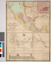
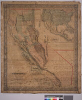
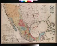
Map of Mexico, including Yucatan and Upper California, exhibiting the chief cities and towns, the principal travelling routes, etc.; and, Map of the principal roads from Vera Cruz and Alvarado to the city of Mexico, including the Valley of Mexico, mountians, plains, volcanoes, lakes, etc. Description: Digitization took place as part of the California Cultures Project. Date: circa 1847 Resource Type: still image Collection: Maps of Los Angeles, California, the United States and the World, circa 1516-1970
New map of California by Charles Drayton Gibbes from his own and other recent surveys and explorations Description: Digitization took place as part of the California Cultures Project. Date: 1852 Resource Type: still image Collection: Maps of Los Angeles, California, the United States and the World, circa 1516-1970
Mapa de los Estados Unidos de Mejico, segun lo organizado y definido por las varias actas del Congreso de dicha republica : y construido por las mejores autoridades Description: Digitization took place as part of the California Cultures Project. Date: 1949 Resource Type: still image Collection: Maps of Los Angeles, California, the United States and the World, circa 1516-1970