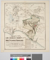
Relief shown by hachures. Shows drainage, township and section lines, land ownership, ranchos, settlements, railroads, etc. Los Angeles and San Pedro railroad shown as well as projected railroads from Los Angeles to San Berndardino, to Anaheim and from Compton to Anaheim.
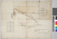
"Suveyed under instruction from the U.S. Surveyor General by Henry Hancock, Dep. Sur., November 1867. Containing 30,144 88/100 acres.""The field noted of the Rancho Muscupiabe from which this plat has been made, have been examined and approved, and are on file in this office. U.S. Surveyor General's Office, San Francisco, California. July 11th, 1868. Signed [], U.S. Surv. Gen. Cal."Boundaries are over drawn in red and green.Includes table of boundary distances.Property at the mouth of the Cajon Pass conferred to Michael Claringbund White (1801-1888) in 1843.80 chains to 1 inch.