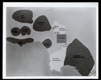
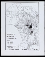
Map of California land grants held by people of African descent from 1784 to 1810
- Description:
- Map showing the locations of California Rancho land grants based on size and on the ethnic classification of the original, or early, recipient of the land grant. It indicates ranchos owned by people of African descent. This includes: Rancho Simi, (Javier, Patricio and Miguel Pico); Rancho San Fernando, (Juan Francisco Reyes); Rancho Topanga Malibu Sequit, (Jose Bartolome Tapia); and Rancho Los Nietos, (José Manuel Nieto).
- Date:
- [undated]
- Resource Type:
- still image
- Collection:
-
Miriam Matthews Photograph Collection
OpenUCLA Collections