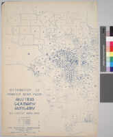
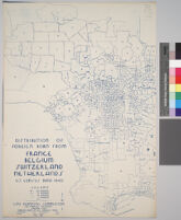
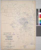
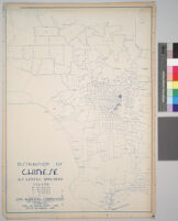
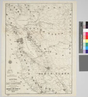
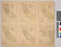
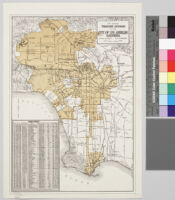
All maps use the same grid, showing cities and towns in Los Angeles County, as well as boundary lines of the adjoining counties and some features and delineations of cities surrounding LA County (within the map's borders). A legend of various sized dots is given for each map, from the largest dot representing the highest population figure per dot to the smallest dot representing the smallest population figure this number varies per map. In rare cases, some population figures are represented by dots for some of the adjoining (non-LA County) cities
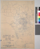
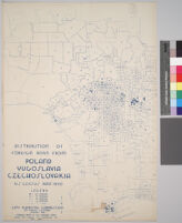
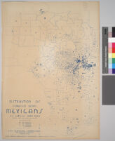
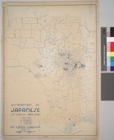
All maps use the same grid, showing cities and towns in Los Angeles County, as well as boundary lines of the adjoining counties and some features and delineations of cities surrounding LA County (within the map's borders). A legend of various sized dots is given for each map, from the largest dot representing the highest population figure per dot to the smallest dot representing the smallest population figure this number varies per map. In rare cases, some population figures are represented by dots for some of the adjoining (non-LA County) cities
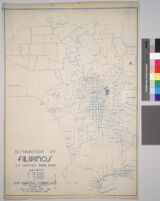
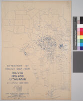
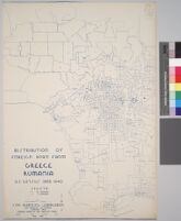
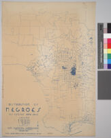
All maps use the same grid, showing cities and towns in Los Angeles County, as well as boundary lines of the adjoining counties and some features and delineations of cities surrounding LA County (within the map's borders). A legend of various sized dots is given for each map, from the largest dot representing the highest population figure per dot to the smallest dot representing the smallest population figure this number varies per map. In rare cases, some population figures are represented by dots for some of the adjoining (non-LA County) cities
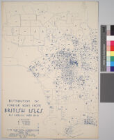
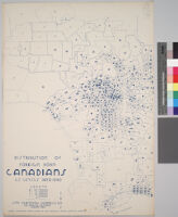
All maps use the same grid, showing cities and towns in Los Angeles County, as well as boundary lines of the adjoining counties and some features and delineations of cities surrounding LA County (within the map's borders). A legend of various sized dots is given for each map, from the largest dot representing the highest population figure per dot to the smallest dot representing the smallest population figure this number varies per map. In rare cases, some population figures are represented by dots for some of the adjoining (non-LA County) cities
All maps use the same grid, showing cities and towns in Los Angeles County, as well as boundary lines of the adjoining counties and some features and delineations of cities surrounding LA County (within the map's borders). A legend of various sized dots is given for each map, from the largest dot representing the highest population figure per dot to the smallest dot representing the smallest population figure this number varies per map. In rare cases, some population figures are represented by dots for some of the adjoining (non-LA County) cities
All maps use the same grid, showing cities and towns in Los Angeles County, as well as boundary lines of the adjoining counties and some features and delineations of cities surrounding LA County (within the map's borders). A legend of various sized dots is given for each map, from the largest dot representing the highest population figure per dot to the smallest dot representing the smallest population figure this number varies per map. In rare cases, some population figures are represented by dots for some of the adjoining (non-LA County) cities
All maps use the same grid, showing cities and towns in Los Angeles County, as well as boundary lines of the adjoining counties and some features and delineations of cities surrounding LA County (within the map's borders). A legend of various sized dots is given for each map, from the largest dot representing the highest population figure per dot to the smallest dot representing the smallest population figure this number varies per map. In rare cases, some population figures are represented by dots for some of the adjoining (non-LA County) cities
All maps use the same grid, showing cities and towns in Los Angeles County, as well as boundary lines of the adjoining counties and some features and delineations of cities surrounding LA County (within the map's borders). A legend of various sized dots is given for each map, from the largest dot representing the highest population figure per dot to the smallest dot representing the smallest population figure this number varies per map. In rare cases, some population figures are represented by dots for some of the adjoining (non-LA County) cities
All maps use the same grid, showing cities and towns in Los Angeles County, as well as boundary lines of the adjoining counties and some features and delineations of cities surrounding LA County (within the map's borders). A legend of various sized dots is given for each map, from the largest dot representing the highest population figure per dot to the smallest dot representing the smallest population figure this number varies per map. In rare cases, some population figures are represented by dots for some of the adjoining (non-LA County) cities
All maps use the same grid, showing cities and towns in Los Angeles County, as well as boundary lines of the adjoining counties and some features and delineations of cities surrounding LA County (within the map's borders). A legend of various sized dots is given for each map, from the largest dot representing the highest population figure per dot to the smallest dot representing the smallest population figure this number varies per map. In rare cases, some population figures are represented by dots for some of the adjoining (non-LA County) cities
All maps use the same grid, showing cities and towns in Los Angeles County, as well as boundary lines of the adjoining counties and some features and delineations of cities surrounding LA County (within the map's borders). A legend of various sized dots is given for each map, from the largest dot representing the highest population figure per dot to the smallest dot representing the smallest population figure this number varies per map. In rare cases, some population figures are represented by dots for some of the adjoining (non-LA County) cities
All maps use the same grid, showing cities and towns in Los Angeles County, as well as boundary lines of the adjoining counties and some features and delineations of cities surrounding LA County (within the map's borders). A legend of various sized dots is given for each map, from the largest dot representing the highest population figure per dot to the smallest dot representing the smallest population figure this number varies per map. In rare cases, some population figures are represented by dots for some of the adjoining (non-LA County) cities
All maps use the same grid, showing cities and towns in Los Angeles County, as well as boundary lines of the adjoining counties and some features and delineations of cities surrounding LA County (within the map's borders). A legend of various sized dots is given for each map, from the largest dot representing the highest population figure per dot to the smallest dot representing the smallest population figure this number varies per map. In rare cases, some population figures are represented by dots for some of the adjoining (non-LA County) cities
All maps use the same grid, showing cities and towns in Los Angeles County, as well as boundary lines of the adjoining counties and some features and delineations of cities surrounding LA County (within the map's borders). A legend of various sized dots is given for each map, from the largest dot representing the highest population figure per dot to the smallest dot representing the smallest population figure this number varies per map. In rare cases, some population figures are represented by dots for some of the adjoining (non-LA County) cities
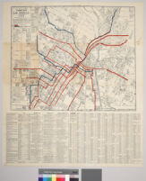
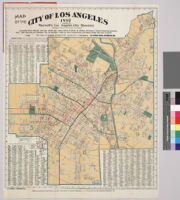
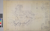
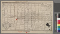
"Showing all streets and street car lines and sewer connections" "Index shows location of streets and shortest routes from centre of city" In lower left hand corner reads: "Compiled in office of Jas. T. Taylor"
"A note of explanantion" on verso, outside when folded Insets: San Francisco-Monterey area -- Los Angeles & vicinity area Produced for the December 1956 Westways, v. 48 No. 12
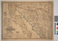
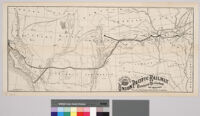
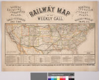
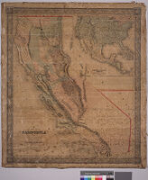
Map of the western United States showing relief by hachures, drainage, cities and towns, stage routes, railroads completed and projected. Main lines in heavy black. Verso of map includes trans-continental time tables, rates of fares, hotel and publisher's advertisements. Map originally folded to 22 x 16.3 cm.
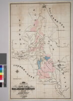
Lots of information about Redondo Beach which "is being developed by the Redondo Beach Company."Street rail lines are marked.Relief shown by hachures.Verso of map has hand written notes on "Deeds 57-386."
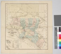
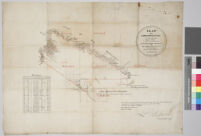
"Suveyed under instruction from the U.S. Surveyor General by Henry Hancock, Dep. Sur., November 1867. Containing 30,144 88/100 acres.""The field noted of the Rancho Muscupiabe from which this plat has been made, have been examined and approved, and are on file in this office. U.S. Surveyor General's Office, San Francisco, California. July 11th, 1868. Signed [], U.S. Surv. Gen. Cal."Boundaries are over drawn in red and green.Includes table of boundary distances.Property at the mouth of the Cajon Pass conferred to Michael Claringbund White (1801-1888) in 1843.80 chains to 1 inch.
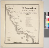
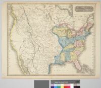
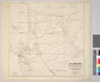
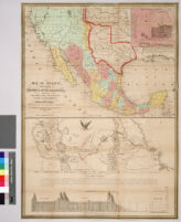
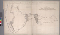
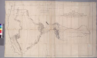
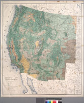
"By Brevet Capt. J.C. Frémont of the Corps of Topographical Engineers under the orders of Col, J.J, Abert, Chief of the Topographical Bureau" "Lith by E. Weber Co., Baltimore, Md."
"By Brevet Capt. J.C. Frémont of the Corps of Topographical Engineers under the orders of Col, J.J, Abert, Chief of the Topographical Bureau" "Lith by E. Weber Co., Baltimore, Md."
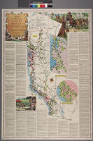
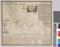
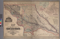
Insets: Town of Cambria Town of Avila Town of San Luis Obispo Town of Morro. Pictorial inset of San Luis Obispo County Courthouse. Shows judicial townships, school districts and Spanish grants (ranchos)
Has orange colored image of a sunset and the word "Sunset" over printed on top half of map. Bordering ranches indicated. East: Rancho San Antonio Rodeo de las Aguas Southeast: Rancho Rincon de los Reyes Southwest: Rancho la Ballona West: Rancho San Vicente.
Property lines marked. Sites of adobe ruins indicated. Inset: Part of Ords Maps, scale 1 inch to 8 chains. Listed on center of sheet: José Antonio Carrillo, José Sepulveda, Francisca Sepulveda, Andronico E. Sepulveda, Vincet Huber, Prudent Beaudry.
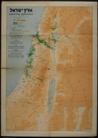
Poster depicts a map of Israel, with international boundaries, armistice boundaries, Jewish cities, Jewish settlements, Arab cities, Arab villages, roads, railroads, rivers, and rivulets (wadis).
Poster is a map of Eretz Israel, depicting Keren Kayemeth and other Jewish lands, "musha" (land held in joint ownership) with Keren Kayemeth and private individuals, Jewish settlements, Arab localities, settlements established by Keren Hayesod, settlements subsidized by Keren Hayesod, and settlements with individual settlers receiving Keren Hayesod subsidies.
Abstract of title of that certain real property in the county of Los Angeles, state of California, bound and described as follows : Rancho San Jose de Buenos Ayres
Continuation by the Title Insurance and Trust Company (p. [288]-291), dated "... this 29th day of January, 1894 ..." (p. 291)Pagination after p. 285 incorrect on item; final 6 leaves have been numbered by leaf rather than by page
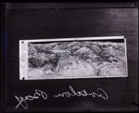
Photograph of a map showing a birds-eye view Avalon Bay on Catalina Island in California. The map, which is pinned down to a board, has renderings of the mountainous island landscape.
![Map of the marked historical sites of California : compiled from the official registrations of the California State Department of Natural Resources [verso]](https://iiif.library.ucla.edu/iiif/2/ark%3A%2F21198%2Fz1k662qr/full/!200,200/0/default.jpg)
![Map of St. Louis and San Francisco R[ailwa]y and connections](https://iiif.library.ucla.edu/iiif/2/ark%3A%2F21198%2Fzz0015wtvz/full/!200,200/0/default.jpg)
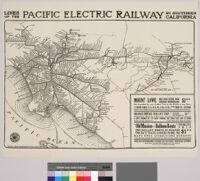
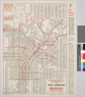
![Relief map of territory served by lines of [the] Pacific Electric Railway in Southern California; largest electric railway system in the world](https://iiif.library.ucla.edu/iiif/2/ark%3A%2F21198%2Fzz0015zqdp/full/!200,200/0/default.jpg)

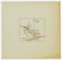
![Map of the subdivision of Rancho San Jose de Buenos Ayres and the town of Sunset, owned by [the] Los Angeles & Santa Monica Land & Water Co.](https://iiif.library.ucla.edu/iiif/2/ark%3A%2F21198%2Fzz0015zqk8/full/!200,200/0/default.jpg)

![Map of the United States, Canada, Mexico and the West Indies with Central America, showing all the routes to California with a table of distances [cover]](https://iiif.library.ucla.edu/iiif/2/ark%3A%2F21198%2Fzz001d1csb%2Ffn85mg6h/full/!200,200/0/default.jpg)
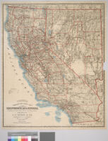
![Bancroft's map of California, Nevada, Utah and Arizona [cover]](https://iiif.library.ucla.edu/iiif/2/ark%3A%2F21198%2Fzz001d1g81%2F52520c5d/full/!200,200/0/default.jpg)