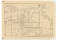
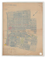
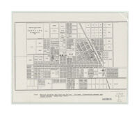
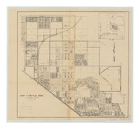
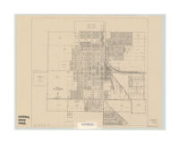
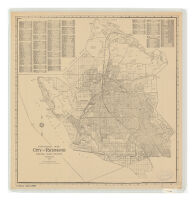
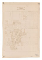
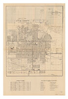
City of Glendora Description: Shows buildings, section and tract numbers, and names of landowners. Date: 1926 Resource Type: cartographic Collection: Henry J. Bruman Map Collection
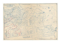
Map of tracts no. 9687, 10467, & 7792 : showing subdivision plan of Ganesha Heights tract, Pomona, California Description: Includes lot numbers and acreages. Date: 1930 Resource Type: cartographic Collection: Henry J. Bruman Map Collection
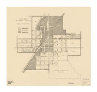
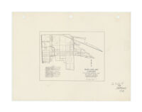
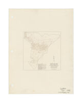
Key map, Dixon City Date: [1938?] Resource Type: cartographic Collection: Henry J. Bruman Map Collection
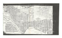
Map of the city of Long Beach, Los Angeles County, California Description: compiled, from official records and from other reliable data, by C.I. Goucher, C.E. Date: [190-?]1900 Resource Type: cartographic Collection: Henry J. Bruman Map Collection
Block data map, Maywood : real property inventory--1939 Description: "Work Projects Administration project-no. 665-07-3-269." Date: [1939] Resource Type: cartographic Collection: Henry J. Bruman Map Collection
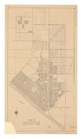
Map of the city of El Segundo : compiled from the records of Los Angeles County, California Description: Includes inset location map. Date: 1932 Resource Type: cartographic Collection: Henry J. Bruman Map Collection
Map of the city of Long Beach, Los Angeles County, California Description: compiled, from official records and from other reliable data, by C.I. Goucher, C.E. Date: [1944?]1900[190-?] Resource Type: cartographic Collection: Henry J. Bruman Map Collection
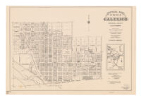
Official map of the city of Calexico, Imperial County, California Description: "Adopted as the official map of the city of Calexico, Oct. 26th, 1920." Date: 1920 Resource Type: cartographic Collection: Henry J. Bruman Map Collection
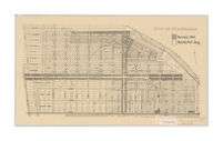
Block data map, Vernon : real property inventory, 1939 / the Housing Authority of the County of Los Angeles. Description: "Work Projects Administration project-no. 665-07-3-269." Date: 1939 Resource Type: cartographic Collection: Henry J. Bruman Map Collection
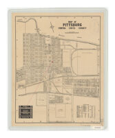
Map of Pittsburg, Contra Costa County Description: Oriented with north toward upper left. Date: 1930[193-?] Resource Type: cartographic Collection: Henry J. Bruman Map Collection
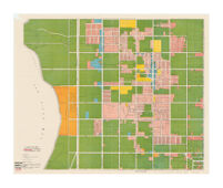
Land utilization of the City of Santa Monica Description: Blueline print used as base map: City of Santa Monica / Howard B. Carter, City Engineer, 1926. Date: 1933 Resource Type: cartographic Collection: Henry J. Bruman Map Collection
Map of the city of Chino / Henry Garrett. Description: Covers area bounded generally by Walnut St., Ramona Ave., Edison Ave., and Magnolia. Date: 1940 Resource Type: cartographic Collection: Henry J. Bruman Map Collection
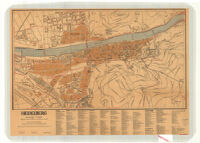
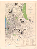
Town Plan of Düsseldorf Date: 1943 Resource Type: cartographic Collection: Henry J. Bruman Map Collection
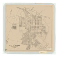
Map of city of Redding : Shasta County, California Description: North shown toward upper right. Date: [1941] Resource Type: cartographic Collection: Henry J. Bruman Map Collection
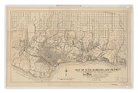
Map of Santa Barbara and vicinity Description: Shows "Paved roads, 1922." Date: 1922[ca. 1922] Resource Type: cartographic Collection: Henry J. Bruman Map Collection
Map of Pacific Grove, California Description: Erwin Dames, City Engineer. Date: 1943 Resource Type: cartographic Collection: Henry J. Bruman Map Collection
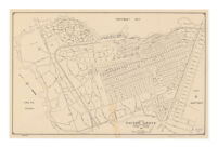
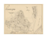
Rossmoyne / W.S. Althouse, civil engineer. Description: Shows tract and lot numbers in the vicinity of Royal Boulevard, north of W.F. Markham estate. Date: [ca. 1926] Resource Type: cartographic Collection: Henry J. Bruman Map Collection
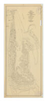
Map of the subdivided portion of the city of Avalon, Santa Catalina Island, California Description: A.B. Waddingham, civil engineer. Date: [1920?] Resource Type: cartographic Collection: Henry J. Bruman Map Collection
Block data map, Lynwood : real property inventory--1939 Description: UCLA copy has pencilled notes on verso: "R.&S. 1079-4" and "map no. 5200 Index." Date: [1939] Resource Type: cartographic Collection: Henry J. Bruman Map Collection
Benicia, Cal. 2 Description: Shows Benicia Agricultural Works. Date: 1979 Resource Type: cartographic Collection: Henry J. Bruman Map Collection
Map of the town of Santa Ana, Los Angeles Co., Cal., 1887 Description: From: Southern California paradise : history of Santa Ana City and Valley, its past, flourishing present and bright future. 1887. Date: 1887 Resource Type: cartographic Collection: Henry J. Bruman Map Collection
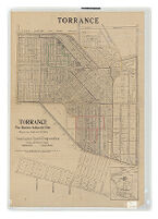
Torrance : the modern industrial city : between Los Angeles and its harbor Description: "Torrance Tract as per map recorded in book 22, pages 94 and 95 of Maps of the records of Los Angeles County." Date: [ca. 1921] Resource Type: cartographic Collection: Henry J. Bruman Map Collection
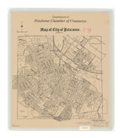
Map of city of Petaluma Description: drawn and compiled by Horwege & Jones. Date: [1916] Resource Type: cartographic Collection: Henry J. Bruman Map Collection
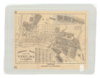
Thomas Bros. map of Ventura, California Description: "447"--Lower right. Date: [1944?] Resource Type: cartographic Collection: Henry J. Bruman Map Collection
Block data map, Montebello : real property inventory--1939 Description: UCLA copy has pencilled notes on verso: "R.&S. 1079-2" and "map no. 5202." Date: [1939] Resource Type: cartographic Collection: Henry J. Bruman Map Collection
City of Signal Hill Description: "3-25-31 L.E.I."--Lower left. Date: 1931 Resource Type: cartographic Collection: Henry J. Bruman Map Collection
Land use map, Chula Vista, California : as of February, 1945 Description: Shows land usage, lot numbers and parcel sizes. Date: 1945 Resource Type: cartographic Collection: Henry J. Bruman Map Collection
City of Maywood Description: Shows tract and lot numbers, business zones, residential zones. Date: [1930?] Resource Type: cartographic Collection: Henry J. Bruman Map Collection
Map of the City of Oxnard Description: E.O. Imus, city engineer. Date: 1944 Resource Type: cartographic Collection: Henry J. Bruman Map Collection
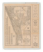
Thomas Bros. map of Redondo Beach, Manhattan Beach, Hermosa Beach, Los Angeles County Description: compiled and published by Thomas Bros. Date: 193u[193-?] Resource Type: cartographic Collection: Henry J. Bruman Map Collection
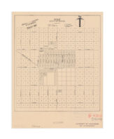
Industrial map, city of Richmond : Contra Costa County, California Description: Shows acreages, and block and lot numbers. Date: 1930 Resource Type: cartographic Collection: Henry J. Bruman Map Collection
City of Huntington Beach, Orange County, California Description: Shows streets, tract names and numbers, block numbers and lot numbers. Date: [1925] Resource Type: cartographic Collection: Henry J. Bruman Map Collection
Map of the city of Delano, Kern County, California Description: Brown line print. Date: [1940?] Resource Type: cartographic Collection: Henry J. Bruman Map Collection
Map of the city of Corona, Riverside Co. California / Currie Engineering Co. Description: Corona Chamber of Commerce. Date: 1928 Resource Type: cartographic Collection: Henry J. Bruman Map Collection
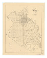
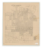
City of Monrovia, Los Angeles Co., California Description: Shows ranges, sections, streets, tracts, lot numbers (some with acreage). Date: [ca. 1913?] Resource Type: cartographic Collection: Henry J. Bruman Map Collection
Plano de las ciudades de Mexicali, Tijuana y Calexico Description: Includes statistics of demographic information, main farm products and major business types. Date: [1929?] Resource Type: cartographic Collection: Henry J. Bruman Map Collection
Map of the city of Monrovia, Los Angeles Co., California : compiled from records and surveys Description: "Compliments of Citizens Bank of Monrovia and Citizens Securities Corportation of Monrovia." Date: 1930 Resource Type: cartographic Collection: Henry J. Bruman Map Collection
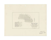
Unrecorded map of Whitley Park : showing existing and proposed subdivision : also golf course, parks & recreational features Description: Shows lot numbers, measurements and sizes. Date: 1929 Resource Type: cartographic Collection: Henry J. Bruman Map Collection
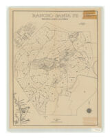
Rancho Santa Fe, San Deigo County, California Description: Includes location map. Date: 1929 Resource Type: cartographic Collection: Henry J. Bruman Map Collection
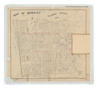
Map of Berkeley, Alameda County, Cal. Description: Overprinted in red: Choice property for sale by Jos. J. Mason, Berkeley. Date: 1899 Resource Type: cartographic Collection: Henry J. Bruman Map Collection