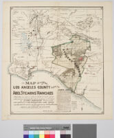
Search

  • Maps of Los Angeles, California, the United States and the World, circa 1516-1970[remove]1

Search Constraints

You searched for: Subject Land grants--California--Orange County--Maps Remove constraint Subject: Land grants--California--Orange County--Maps Genre cartographic Remove constraint Genre: cartographic Resource Type still image Remove constraint Resource Type: still image Location Los Angeles County (Calif.)--Maps Remove constraint Location: Los Angeles County (Calif.)--Maps Collection Maps of Los Angeles, California, the United States and the World, circa 1516-1970 Remove constraint Collection: Maps of Los Angeles, California, the United States and the World, circa 1516-1970 Subject Real property--California--Los Angeles County--Maps Remove constraint Subject: Real property--California--Los Angeles County--Maps Subject Landowners--California--Los Angeles County--Maps Remove constraint Subject: Landowners--California--Los Angeles County--Maps
Start Over

Search Results

Map of a portion of Los Angeles County showing the Abel Stearns' ranches : La Habra, Los Coyotes, San Juan Cajon, Las Bolsas, La Bolsa Chica