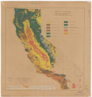
State of California, natural cover and agricultural land-use Description: Hand colored. Date: 1934 Resource Type: cartographic Collection: Henry J. Bruman Map Collection
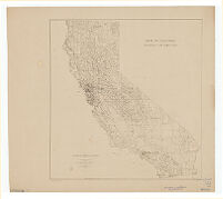
State of California, rainfall distribution Description: Brown line print. Date: 1934 Resource Type: cartographic Collection: Henry J. Bruman Map Collection
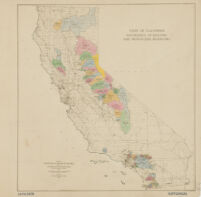
State of California, watersheds of existing and proposed reservoirs Description: prepared for National Resources Board and the California State Planning Board, Land-Use Adjustment Survey ; submitted by Land Planning Consultant for California. Date: 1934 Resource Type: cartographic Collection: Henry J. Bruman Map Collection