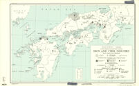
Using Digital Collections Content
About
Give Us Feedback
Search in
search for
Search
All Fields
Title
Subject
Search
Browse items
Subject
Japan--Maps
195
Germany--Maps
157
Los Angeles (Calif.)--Maps
128
France--Maps
110
United States -- Maps
109
more
Subject
»
Resource Type
cartographic
✕
[remove]
3,612
still image
31
Genre
map
3,518
Road maps.
77
Pictorial maps.
50
Thematic maps.
49
Topographic maps.
49
more
Genre Sim
»
Names
Historic Urban Plans (Firm).
19
California. Division of Mines.
6
Geological Survey (U.S.).
5
A.L. Bancroft & Company.
4
California. Land-use Adjustment Survey.
4
more
Named Subject Sim
»
Location
California
363
Japan
210
Germany
156
United States
151
Los Angeles (Calif.)
130
more
Location Sim
»
Date
Date range begin
–
Date range end
Current results range from
1480
to
2005
View distribution
Unknown
1,187
Language
English
2,674
German
263
French
180
Spanish
146
Latin
115
more
Human Readable Language Sim
»
Collection
Henry J. Bruman Map Collection
3,034
East Asian Maps in the Bruman Collection
485
Southern African Maps in Books
62
Maps Showing Distribution of Racial and National Groups in Los Angeles, according to the 1940 United States Census
14
Historic Cairo Architectural Mapping
7
more
Collection
»
Repository
University of California, Los Angeles. Library. Henry J. Bruman Map Collection
3,031
University of California, Los Angeles. Library. Department of Special Collections
14
American Research Center in Egypt
7
Fazenda Ibicaba (Cordeirópolis, SP)
1
Program
International Digital Ephemera Project
7
Search Constraints
You searched for:
Resource Type
cartographic
✖
Remove constraint Resource Type: cartographic
Start Over
3612
Catalog Results
Sort by Relevance
Relevance
Title (A-Z)
Title (Z-A)
Date (newest)
Date (oldest)
Number of results to display per page
100 per page
10
per page
20
per page
50
per page
100
per page
View results as:
List
Created with Sketch.
List View
List
Gallery
Created with Sketch.
Gallery View
Gallery
‹ Prev
Next ›
1
2
…
32
33
34
35
36
37
Search Results
Japan: Karafuto, town plan of Ochiai
Suiyan Province
Kwangsi Province
Manchuria Mineral Deposits Board Of Economic Warefare, Enemy Branch
War Map Of China And Far East Showing Japanese Aggression
Japan In The Pacific
Japan, motor roads and ports
Southwest Japan (Kyushu, Shikoku, And Southwest Honshu) Distribution Of Population
Japan Cities Over 100,000 Population 1930
Government Railways
Southern Japan
Central Japan (Central And Northern Honshu) Cities (Shi) / Size And Functional Type / Population (1940 Census)
Japan: Food Sufficiency
Kobe Density Of Population 1940
The official map of Orange County, California and portions of adjoining counties
Bancroft's map of California, Nevada, Utah and Arizona [cover]
Kaart van Natalia en van Afrika's zuidhoek opgemaakt in 1846 door G. Lauts
Skeleton map of a portion of the eastern frontier of the Cape of Good Hope
Map illustrative of tour of Messrs. Arbonsset & Doumos
Sketch of Natal, showing its proposed divisions, towns, villages, &c.
Sketch showing the site of operations near Thaba Bosigo
[Map of the Cape of Good Hope]
Natal and Kaffraria
Cape Colony
Route of Burchell's Travels
Chart of Port Natal
Mauritius or Isle of France
Africa. European possessions in 1884, before the Berlin Conference
Sketch of the sovereignty beyond the Orange River
Van Diemen's Island or Tasmania
Sketch map of the seat of war
Map of South Africa
Africa
Topographical sketch of the Kat River settlement, & adjacent country
A general mapp of the sea coasts of Africa from the Cape of Good Hope to Cape Guardafoy with the inhabited islands in those seas
A chart of the southern extremity of Africa
Plan to show the military posts for the occupation of the Amatolas
Kostantinah, and its immediate environs. 1837
Sketch of the British Colonies South Africa
South Africa; compiled from the M.S. maps in the Colonial Office
The ceded territory on the Caffer frontier; with the district of Albany, and part of Somerset
Map of the Colony of Natal from the Umzimvubu River to Point Durnford
Kaart von Zuid-Afrika
Base map of China
China, south coast, intensity of cultivation by hsien
Mineral deposits of Hainan Island
Hai-Nan Tao agricultural regions (generalized)
Northwest China, generalized soil types
Manchoutikuo And Adjoining Territories
Sketch Plan Of Shih-Ch'i & Hsiang-Shan
Yunnan
Key Map Of Hong Kong Relative To Canton And Macao
Eastern China, principal languages : needed by interpreters in these areas
China, south coast, political divisions : including emigration areas and mission stations
Nihon Teikoku chishitsu zu = : Geological map of Japanese Empire
Southwest Japan (Kyushu, Shikoku, And Southwest Honshu) Iron And Steel Industry / Iron Mines And Deposits
Japan
Japan Population Changes 1935-1940
Relief Map Of Southern Japan
Population Densities In Japan
Tokyo
Agriculture in Japan
China, East Coast Motor Roads And Railroads
Japan, acreage of rice by prefectures, 1939 ; Japan, acreage of wheat by prefectures, 1939
North China Natural Availability Of Water
Agricultural Areas Of China
Japan: Kagoshima-Ken
Japan: Nagasaki-Ken
T'u-Ch'ang
Map Of The Routes Of Russian Explorers In China And Eastern Thilet
Japan and adjacent regions of Asia and the Pacific Ocean
Japan: population densities by prefectures and province
Japan
Manchuria: Map Coverage By Russian And Japanese Agencies
Japan: Gumma-Ken
Japan: Ehime-Ken
China
[Na]
Korea city plans 1:12,500 : Pʻyongyang (Heijō)
Sketch plan of P'ohang-Dang (Hokō-dō)
Korea
Korea : or, Tscho-sen of the Japanese
Japan cities and towns : (shi and machi)
Outline Map Of Japan And Manchuria
Japan 1940 Census Subdivisions Ken, Gun And Shi
Ostasien
Mandchourie - Japan Et Chine Du Nord
Chahar and Jehol provinces
North China percentage of cultivation by hsien
Southwest Japan (Kyushu, Shikoku, And Southwest Honshu) Surpluses And Deficits Of Food Resources / Combined Averages (1935, 1937, 1939) Of All Food...
Japan : distribution of population (1913)
Southwest Japan (Kyushu, Shikoku, And Southwest Honshu) Non-Metallic Mineral Production
Southwest Japan (Kyushu, Shikoku, And Southwest Honshu) Industrial Concentration 1943
Daijurin-San Sw
Japanese Plan: Co-Prosperity Sphere (1853 19?)
Korea road map 1:700,000
Japan: Karafuto, town plan of Ōtomari
topographic map of Manchoukuo
Manchuria 1:250,000
China, South Coast: Water Supply
See More Results
‹ Prev
Next ›
1
2
…
32
33
34
35
36
37