Maps of city of Los Angeles
Item Overview
- Title
- Maps of city of Los Angeles
- Date Created
- 1923
- Place of Origin
- Los Angeles, Calif
- Publisher
- Clason Map Company
- Collection
- Maps of Los Angeles, California, the United States and the World, circa 1516-1970
Notes
- Description
-
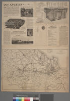
Includes street index. Above map is photographic image: "Section of Los Angeles skyline--looking north down Broadway from Tenth Street"
Digitization took place as part of the California Cultures Project.
scale not given
On top half of verso is ancillary map: "Clason's map of Los Angeles district c. 1922"
Panel title: "Map of Los Angeles, the climate capital of the new world"
Caption on verso: "Los Angeles -- the year round city". Verso is filled with promotional information about the city.
Physical Description
- Extent
- 1 map
- Dimensions
- 59 x 51.5 cm. on sheet 71 x 53.5 cm.; 59 x 51.5 cm. on sheet 71 x 53.5 cm.
Find This Item
- Repository
- University of California, Los Angeles. Library. Department of Special Collections
- ARK
- ark:/21198/zz001616rx
- Manifest url
-

Access Condition
- Rights statement
- public domain