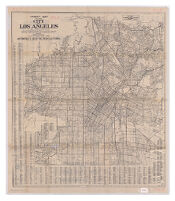
Street map of the city of Los Angeles, California, showing street names together with principal routes in and out of the congested district
Item Overview
- Title
- Street map of the city of Los Angeles, California, showing street names together with principal routes in and out of the congested district
- Alternative title
-
Annexations of the city of Los Angeles
Street map of Los Angeles city and annexations - Creator
- Automobile Club of Southern California. Route and Map Service Department.
- Date Created
- 193u
- Place of Origin
-
cau
Los Angeles, Cal - Publisher
- The Club
- Language
- English
- Collection
- Henry J. Bruman Map Collection
Notes
- Description
-
Includes Forest Lawn Cemetery.
Panel title: Street map of Los Angeles city and annexations.
Relief represented by spot heights.
prepared by the Route and Map Service Department, Automobile Club of Southern California.
"1136."
Indexed.
On verso: map of "Annexations of the city of Los Angeles," "1137," and 2 insets.
Physical Description
- Extent
- 1 map ; 89 x 77 cm, folded to 25 x 11 cm
Keywords
- Genre
- map
- Subject Geographic
- Los Angeles (Calif.)--Road maps
- Location
- Los Angeles (Calif.)
- Resource type
- cartographic
Find This Item
- Repository
- University of California, Los Angeles. Library. Henry J. Bruman Map Collection
- ARK
- ark:/21198/zz002c23ks
- Opac url
- https://search.library.ucla.edu/permalink/01UCS_LAL/17p22dp/alma995342353606533
- Manifest url
-

Access Condition
- Rights statement
-
unknown
public domain