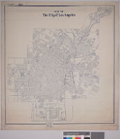
Map of the city of Los Angeles
Item Overview
- Title
- Map of the city of Los Angeles
- Date Created
- 1903
- Place of Origin
- Los Angeles, Calif. (?)
- Language
- English
- Collection
- Maps of Los Angeles, California, the United States and the World, circa 1516-1970
Notes
- Description
-
Digitization took place as part of the California Cultures Project.
Relief shown by hachures. Includes streets, parks and railways. Boyle Heights included.
scale: 1:65,840
Physical Description
- Extent
- 1 map : blueline print
- Dimensions
- 93.5 x 83.5 cm. on sheet 98.5 x 90 cm.
Keywords
- Genre
-
maps
cartographic - Location
-
Los Angeles (Calif.)--Maps
Boyle Heights (Calif.)--Maps - Resource type
- still image
Find This Item
- Repository
- University of California, Los Angeles. Library. Department of Special Collections
- ARK
- ark:/21198/zz00096dgs
- Manifest url
-

Access Condition
- Rights statement
- public domain