Palisades
Item Overview
- Title
- Palisades
- Date Created
- n.d.
- Language
- English
- Collection
- Tract Maps and Cadastral Maps of Southern California, 1868-1937
Notes
- Description
-
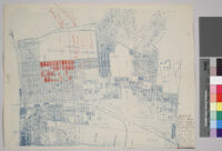
All tracts are identified and numbered, with a few shaded in red. Boundaries of Rancho San Vicente in red.
Digitization took place as part of the California Cultures Project.
Scale not given
Covers parts of present day Brentwood, Pacific Palisades, and West Los Angeles as well as Santa Monica
UCLA copy has hand written in the bottom right corner: "Street work $85.00 a lot for 50 ft. and payment for same to extend over period of 10 years. Price $800.00 a lot 50 x 150 to alley, not incl. street work or $18.00 to 20 a foot with improvements"
Physical Description
- Extent
- 1 map: blueprint
- Dimensions
- 35.5 x 44 cm. on sheet 37 x 49 cm.
Keywords
- Genre
-
cartographic
cadastral maps - Location
-
Brentwood (Los Angeles, Calif.)--Maps
Santa Monica (Calif.)--Maps
West Los Angeles (Los Angeles, Calif.)--Maps
Pacific Palisades (Los Angeles, Calif.)--Maps - Resource type
- still image
- Subjects
-
Real property--California--Santa Monica--Maps
Real property--California--Los Angeles--Maps
Find This Item
- Repository
- University of California, Los Angeles. Library Special Collections
- Local Identifier
-
clusc_1_1_00017043a
uclamss_349_b1_5 - ARK
- ark:/21198/zz001d2s6s
- Manifest url
-

Access Condition
- Rights statement
- unknown