Pictorial map of the Los Angeles business district, 1890s (?)
Item Overview
- Title
- Pictorial map of the Los Angeles business district, 1890s (?)
- Alternative title
- Maps and Demography of Los Angeles
- Date Created
- [1890s (?)]
- Date
- 1890/1900
- Collection
-
Miriam Matthews Photograph Collection
OpenUCLA Collections
Notes
- Description
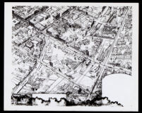
- Pictorial map depicting a bird's-eye view of streets, and buildings in downtown Los Angeles with Alameda on the right, San Pedro St. on the left, Second street near the bottom and Requena (renamed Market) near the top. It includes dwellings, commercial structures, and names of streets. It also shows train, and electric rail routes.
- Caption
- Written on back of map: View showing Los Angeles Business District. Courtesy L.A. County Museum (Natural History).
Physical Description
- Extent
- 1 map
Find This Item
- Local Identifier
- uclalsc_1889_b17_f06_002a.tif
- ARK
- ark:/21198/z12z2pnq
- Manifest url
-

Access Condition
- Rights statement
- unknown
- Rights contact
- spec-coll@library.ucla.edu