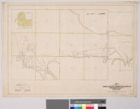
Map of a portion of the Agua Caliente Indian Reservation, Riverside County, California
Item Overview
- Title
- Map of a portion of the Agua Caliente Indian Reservation, Riverside County, California
- Date Created
- 1919
- Place of Origin
- [Washington, D.C.]
- Publisher
- United States. Office of Indian Affairs. Irrigation Division
- Language
- English
- Collection
- Maps of Los Angeles, California, the United States and the World, circa 1516-1970
Notes
- Description
-
Inset: "Map of Agua Caliente Indian Reservation"
Digitization took place as part of the California Cultures Project.
scale: 1:12,000
Relief shown by hachures. Irrigation pipelines are marked.
"Drawn by I.F.W."
Physical Description
- Extent
- 1 map
- Dimensions
- 50 x 71 cm. on sheet 54 x 76 cm.
Keywords
- Genre
-
maps
cartographic - Location
- Agua Caliente Indian Reservation (Calif.)--Maps
- Resource type
- still image
- Subjects
- Irrigation--California--Agua Caliente Indian Reservation--Maps
Find This Item
- Repository
- University of California, Los Angeles. Library Special Collections
- ARK
- ark:/21198/zz00096f7n
- Manifest url
-

Access Condition
- Rights statement
- public domain