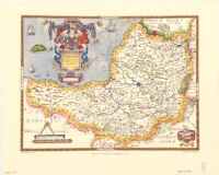
Saxton’s map of Somerset, 1575
Item Overview
- Title
- Saxton’s map of Somerset, 1575
- Uniform title
- Somersetensem comitat’ (agri fertilitate celebrem) hoc ob oculos ponit tabula, anno 1575 et D Elizabethe Regine, A’o 17
- Creator
-
Saxton, Christopher. b. 1542?.
Taylowe Limited.
Great Britain. Her Majesty's Stationery Office.
Terwoort, Lenaert. - Date Created
- 1961
- Date
- 1961
- Place of Origin
-
[London?
enk - Publisher
- H.M.S.O.]
- Language
-
English
Latin - Collection
- Henry J. Bruman Map Collection
Notes
- Description
-
Christophorus Saxton descripsit ; Leonardvs Terwoort Antverpianvs scvlpsit.
In lower margin: Saxton's map of Somerset, 1575.
Original version: [London : s.n., 1575].
In lower left corner: British Museum. Maps C.7. c.I.
Relief represented pictorially.
Includes col. ill. and coat of arms.
Facsimile.
Physical Description
- Extent
- 1 map : col. ; 38 x 50 cm.
Keywords
- Genre
- map
- Subject Geographic
- Somerset (England)--Maps--Early works to 1800
- Location
- Somerset (England)
- Resource type
- cartographic
- Subjects
-
Early maps--Facsimiles
Somerset (England)--Maps--Early works to 1800
Find This Item
- Repository
- University of California, Los Angeles. Library. Henry J. Bruman Map Collection
- ARK
- ark:/21198/zz002cf79h
- Opac url
- https://search.library.ucla.edu/permalink/01UCS_LAL/17p22dp/alma9942782163606533
- Manifest url
-

Access Condition
- Rights statement
- unknown