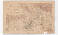
California (Los Angeles Co.) Los Angeles sheet
Item Overview
- Title
- California (Los Angeles Co.) Los Angeles sheet
- Alternative title
- Los Angeles sheet, California (Los Angeles Co.)
- Creator
-
Fletcher, L. C.
Thompson, A. H. (Almon Harris). 1839-1906.
Geological Survey (U.S.).
Gerdine, T. G.
Davis, A. P.
Cormack, Robert.
Post, W. S.
Gannett, Henry. 1846-1914.
California Art & Engraving Co.
Goode, Richard Urquhart. 1858-1903. - Date Created
- 1897
- Place of Origin
-
[Washington, D.C.]
cau
dcu
Berkeley - Publisher
-
The Survey
California Art & Engrving Co. - Language
- English
- Collection
- Henry J. Bruman Map Collection
Notes
- Description
-
Cartographer: Robert Cormack.
Relief represented by contours.
Cartoon map.
Oriented with north toward upper right.
Includes compilation diagram.
"Surveyed in 1893-94."
Extends from the Central Valley to the Comstock Lode, Nevada.
U.S. Geological Survey ; Henry Gannett, chief topographer ; A.H. Thompson and R.U. Goode, geographers in charage ; triangulation by A.P. Davis ; topography by L.C. Fletcher, W.S. Post and T.G. Gerdine.
Contour interval 50 feet. Datum is mean sea level. - Note
- Ed. of Feb. 1897.
Physical Description
- Extent
-
1 map : col. ; 45 x 74 cm.
1 map : col. ; 58 x 43 cm.
Keywords
- Genre
- map
- Subject Geographic
-
California--Maps
Los Angeles County (Calif.)--Maps
Los Angeles Metropolitan Area (Calif.)--Maps
Mother Lode (Calif.)--Maps
Comstock Lode (Nev.)--Maps
Los Angeles (Calif.)--Maps - Location
-
Los Angeles County (Calif.)
Los Angeles Metropolitan Area (Calif.)
Los Angeles (Calif.)
Mother Lode (Calif.)
Comstock Lode (Nev.)
California - Resource type
- cartographic
Find This Item
- Repository
- University of California, Los Angeles. Library. Henry J. Bruman Map Collection
- ARK
- ark:/21198/zz002c1nbf
- Opac url
- https://search.library.ucla.edu/permalink/01UCS_LAL/17p22dp/alma9966396393606533
- Manifest url
-

Access Condition
- Rights statement
- pd_usfed