ארץ ישראל = Eretz Israel
Item Overview
- Title
- ארץ ישראל = Eretz Israel
- Alternative title
- Erets Yiśraʼel
- Creator
- Pikovsky, M.
- Date Created
- [1940s]
- Date
- 1940/1949
- Place of Origin
- Jerusalem
- Publisher
- Jewish National Fund
- Language
- English
- Collection
- Collection of Zionist Posters Promoting Israel to Diaspora Jews, 1940-1979
Notes
- Description
-
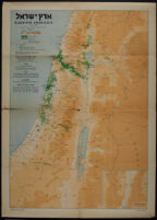
Poster is a map of Eretz Israel, depicting Keren Kayemeth and other Jewish lands, "musha" (land held in joint ownership) with Keren Kayemeth and private individuals, Jewish settlements, Arab localities, settlements established by Keren Hayesod, settlements subsidized by Keren Hayesod, and settlements with individual settlers receiving Keren Hayesod subsidies.
Includes inset of Southern Edom.
Scale 1:500,000 ; 1:1.000.000.
Relief shown by shading. - Caption
-
Goldberg's Press, Jerusalem
Printed in Palestine
LOOK at the area acquired by the Keren Kayemeth in Eretz Israel and settled by the Keren Hayesod. SEE how small and insignificant the Jewish share has hitherto been in the land and settlement of this country, the land of our hopes, and CONSIDER how great are the tasks that still lie before us! THEN YOU WILL KNOW that every man and woman among our people must do his utmost to further the realisation of the great task of redemption of the land and its upbuilding.
Issued by the Head Offices of the Keren Kayemeth Leisrael, Jerusalem
Zincography M. Pikovsky
Physical Description
- Extent
- 1 poster : col.
Keywords
- Genre
-
maps
posters - Location
- Israel : local
- Resource type
-
still image
cartographic - Subjects
-
Israel--History--1948-1967--Maps
Land settlement--Israel--Maps
Find This Item
- Local Identifier
- uclalsc_2147_b1_f05_01
- ARK
- ark:/21198/zz002kcmfg
- Manifest url
-

Access Condition
- Rights statement
- unknown