Korea city plans 1:10,000 : Hungnam (Konan)
Item Overview
- Title
- Korea city plans 1:10,000 : Hungnam (Konan)
- Alternative title
-
[Series] L951
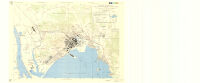
Hungnam, Korea
Hungnam (Konan) Hamgyong Namdo (Kankyo Nando) Korea - Creator
- United States. Army Map Service.
- Date Created
- 1945
- Place of Origin
-
Washington, D.C
dcu - Publisher
- Army Map Service
- Language
- English
- Collection
- East Asian Maps in the Bruman Collection
Notes
- Description
-
Relief represented by contours.
"Contour interval 10 meters ... Depths in fathoms at nearly lowest low water."
"A.M.S. L951."
Three classes of roads or trails, three classes of railroads, and areas of vegetation and cultivation are shown. Some buildings are named.
Includes glossary to Korean, Japanese and English terms, inset map "Index to sources," list of map data sources and notes.
cp
"5-45."
1st ed. AMS 1.
1st ed.
Military grid. - Note
-
southernmost:N0394845
easternmost:E1273900
westernmost:E1273420
easternmost:E1273950
southernmost:N0394900
northernmost:N0395100
westernmost:E1273500
northernmost:N0395140
Physical Description
- Extent
- 1 map : col. ; 55 x 79 cm.
Keywords
- Genre
- map
- Location
-
10000
Hŭngnam-si (Korea)
Korea (North) - Resource type
- cartographic
- Subjects
-
Cities and towns--Korea (North)--Maps
Hŭngnam-si (Korea)--Maps
Find This Item
- Repository
- University of California, Los Angeles. Library. Henry J. Bruman Map Collection
- Local Identifier
-
G7909_10_AMS_1945_HUNGNAM
Monograph_Maps - ARK
- ark:/21198/zz002hgkfh
- Manifest url
-

Access Condition
- Rights statement
- public domain
- Funding Note
- Access to this collection is generously supported by Sammy Yukuan Lee Foundation.