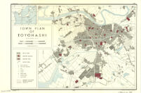
Town plan of Toyohashi
Item Overview
- Title
- Town plan of Toyohashi
- Date Created
- 1944
- Place of Origin
-
[Washington, D.C.]
dcu - Publisher
- Reproduction Branch, Office of Strategic Services
- Language
- English
- Collection
- East Asian Maps in the Bruman Collection
Notes
- Description
-
Provisional ed.
"No. 3808--R & A, OSS."
"19 July 1944."
Includes location map. - Note
-
easternmost:E1372330
northernmost:N0354530
westernmost:E1372330
southernmost:N0354530
Physical Description
- Extent
- 1 map : col. ; 30 x 44 cm.
Keywords
- Genre
- map
- Location
-
Toyohashi-shi (Japan)
20600 - Resource type
- cartographic
- Subjects
- Toyohashi-shi (Japan)--Maps
Find This Item
- Repository
- University of California, Los Angeles. Library. Henry J. Bruman Map Collection
- Local Identifier
-
Monograph_Maps
G7964_21_OSS_1944_EDProv - ARK
- ark:/21198/zz002hfbg6
- Manifest url
-

Access Condition
- Rights statement
- pd_usfed
- Funding Note
- Access to this collection is generously supported by Sammy Yukuan Lee Foundation.