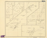
Ryukyu Islands roads, railroads and cables
Item Overview
- Title
- Ryukyu Islands roads, railroads and cables
- Date Created
- 1942
- Place of Origin
-
[Washington]
dcu - Publisher
- O.S.S.
- Language
- English
- Collection
- East Asian Maps in the Bruman Collection
Notes
- Description
-
Provisional ed.
Includes index map.
Sept. 17, 1942.
Drawn in the Geography Division, O.S.S.
"Map no. 931."
"Provisional edition." - Note
-
westernmost:E1270000
easternmost:E1300000
northernmost:N0320000
southernmost:N0260000
Physical Description
- Extent
- 5 maps ; on sheet 39 x 48 cm.
Keywords
- Genre
- map
- Location
-
Ryukyu Islands
Japan - Resource type
- cartographic
- Subjects
-
Railroads--Japan--Ryukyu Islands--Maps
Cables, Submarine--Japan--Ryukyu Islands--Maps
Roads--Ryukyu Islands--Maps
Find This Item
- Repository
- University of California, Los Angeles. Library. Henry J. Bruman Map Collection
- Local Identifier
-
G7962_P1_1_1M_OSS_1942_EDProv
Monograph_Maps - ARK
- ark:/21198/zz002hf7js
- Manifest url
-

Access Condition
- Rights statement
- pd_usfed
- Funding Note
- Access to this collection is generously supported by Sammy Yukuan Lee Foundation.