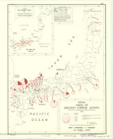
Japan : ports of greatest shipping activity 1934 (entrances and clearances of vessels in gross tons)
Item Overview
- Title
- Japan : ports of greatest shipping activity 1934 (entrances and clearances of vessels in gross tons)
- Date Created
- 1945
- Place of Origin
-
[Washington, D.C.]
dcu - Publisher
- Reproduction Branch, OSS
- Language
- English
- Collection
- East Asian Maps in the Bruman Collection
Notes
- Description
-
Dated: 1 September 1945.
Provisional ed.
Indicates gross tonnage and proportion of sailing vessels.
"No. 6172 -- R & A, OSS."
Inset: Japan secondary ports. - Note
-
westernmost:E1300000
easternmost:E1420000
northernmost:N0420000
southernmost:N0300000
Physical Description
- Extent
- 1 map : col. ; 42 x 31 cm.
Keywords
- Genre
-
map
Thematic maps. - Location
-
3500000
Japan - Resource type
- cartographic
- Subjects
- Shipping--Japan--Maps
Find This Item
- Repository
- University of California, Los Angeles. Library. Henry J. Bruman Map Collection
- Local Identifier
-
G7961_P55_4M_OSS_1945_EDProv
Monograph_Maps - ARK
- ark:/21198/zz002hf63k
- Manifest url
-

Access Condition
- Rights statement
- public domain
- Funding Note
- Access to this collection is generously supported by Sammy Yukuan Lee Foundation.