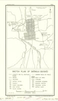
Sketch plan of Chŏngju (Seishū)
Item Overview
- Title
- Sketch plan of Chŏngju (Seishū)
- Creator
-
United States. War Department. Strategic Services Unit. Reproduction Branch.
United States. Department of State. Interim Research and Intelligence Service. Research and Analysis Branch. - Date Created
-
1945
29 December 1945 - Date
- 1945-12-29
- Place of Origin
-
[Washington, D.C.]
dcu - Publisher
- Lithographed in the Reproduction Branch, SSU
- Language
- English
- Collection
- East Asian Maps in the Bruman Collection
Notes
- Description
-
R & A, IRIS.
Provisional ed.
"29 December 1945."
"Data compiled prior to 1 August 1945. Date of information unknown."
"Base map - 1918."
Includes index to points of interest.
"No. 3634."
"Free."
Also available on the Internet through the American Geographical Society Library Digital Map Collection. - Note
-
southernmost:N0363750
northernmost:N0363750
westernmost:E1272920
easternmost:E1272920
Physical Description
- Extent
- 1 map ; 19 x 14 cm., on sheet 31 x 20 cm.
Keywords
- Genre
- map
- Subject Geographic
- Korea--Maps
- Location
-
Ch'ŏngju-si (Ch'ungch'ŏng-bukto, Korea)
15000 - Resource type
- cartographic
- Subjects
- Ch'ŏngju-si (Ch'ungch'ŏng-bukto, Korea)--Maps
Find This Item
- Repository
- University of California, Los Angeles. Library. Henry J. Bruman Map Collection
- Local Identifier
-
Monograph_Maps
G7904_14_7_1R1S_1945_EDProv - ARK
- ark:/21198/zz002hf38q
- Manifest url
-

Access Condition
- Rights statement
- pd_usfed
- Funding Note
- Access to this collection is generously supported by Sammy Yukuan Lee Foundation.