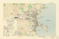
Songjin (Joshin), Hamgyong-Pukto, (Konkyo-Hokudo) Korea
Item Overview
- Title
- Songjin (Joshin), Hamgyong-Pukto, (Konkyo-Hokudo) Korea
- Alternative title
- Sŏngjin (Jōshin), Hamgyŏng-bukto (Kankyō Hokudō) Korea
- Creator
- United States. Army Map Service.
- Date Created
-
1945
June 1945 - Date
- 1945-06
- Place of Origin
-
Washington, D.C
ja - Publisher
- Army Map Service
- Language
-
English
Japanese - Collection
- East Asian Maps in the Bruman Collection
Notes
- Description
-
Relief represented by contours.
"7-45."
Shows roads, structures, topography and vegetation.
"Restricted."
Contour interval 10 meters.
"For use with AAF air objective folder Seishin 84.1."
"June, 1945."
Army Map Service.
cp - Note
-
easternmost:E1291300
easternmost:E1201300
southernmost:N0403900
westernmost:E1291000
northernmost:N0404100
Physical Description
- Extent
- 1 map : col. ; 30 x 47 cm.
Keywords
- Genre
-
Topographic maps.
map - Location
-
12500
Kimch'aek (Korea) - Resource type
- cartographic
- Subjects
- Kimch'aek (Korea)--Maps
Find This Item
- Repository
- University of California, Los Angeles. Library. Henry J. Bruman Map Collection
- Local Identifier
-
G7904_12_5_AMS_1945
Monograph_Maps - ARK
- ark:/21198/zz002hf376
- Manifest url
-

Access Condition
- Rights statement
- pd_usfed
- Funding Note
- Access to this collection is generously supported by Sammy Yukuan Lee Foundation.