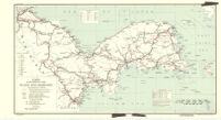
Korea (including Quelpart and Tsushima) roads and railroads
Item Overview
- Title
- Korea (including Quelpart and Tsushima) roads and railroads
- Date Created
- 28 February 1945
- Date
- 1945-02-28
- Place of Origin
-
[Washington, D.C.]
dcu - Publisher
- Reproduction Branch, OSS
- Language
- English
- Collection
- East Asian Maps in the Bruman Collection
Notes
- Description
-
Provisional ed.
"No. 6336 ... 28 February 1945."
Oriented with north to left.
Relief represented by shading.
R & A, OSS.
Inset: Ullŭng-do. - Note
-
easternmost:E1300000
westernmost:E1240000
southernmost:N0340000
northernmost:N0430000
Physical Description
- Extent
- 1 map : col. ; 30 x 55 cm.
Keywords
- Genre
- map
- Subject Geographic
- Korea--Maps
- Location
-
2000000
Korea - Resource type
- cartographic
- Subjects
-
Roads--Korea--Maps
Transportation--Korea--Maps.
Railroads--Korea--Maps
Korea--Maps
Find This Item
- Repository
- University of California, Los Angeles. Library. Henry J. Bruman Map Collection
- Local Identifier
-
G7901_P1_2_4MIL_OSS_1945_EDProv
Monograph_Maps - ARK
- ark:/21198/zz002hf32m
- Manifest url
-

Access Condition
- Rights statement
- pd_usfed
- Funding Note
- Access to this collection is generously supported by Sammy Yukuan Lee Foundation.