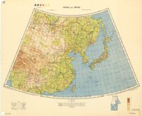
China and Japan
Item Overview
- Title
- China and Japan
- Alternative title
- 中國和日本
- Date Created
- 1943
- Place of Origin
-
Washington, D.C
dcu - Publisher
- Army Map Service, U.S. Army
- Language
- English
- Collection
- East Asian Maps in the Bruman Collection
Notes
- Description
-
Relief represented by contours.
cz
1st ed.-AMS 1.
1st ed. (Reproduced)
"Published by W.O. 1942."
compiled from G.S.G.S. 4065 and 2957.
"Drawn and reproduced by 512 (A. Fd. svy.) coy., R.E., Dec. 1941. Compiled from G.S.G.S. 4065 and 2957."
Marginal map: Index to adjoining sheet [Malaya] and boundaries.
Elevations shown by altitude tints. - Note
-
southernmost:N0200000
easternmost:E1500000
westernmost:E0900000
northernmost:N0560000
Physical Description
- Extent
- 1 map : col. map. 56 x 83 cm.
Keywords
- Genre
-
map
Topographic maps. - Location
-
8000000
East Asia - Resource type
- cartographic
- Subjects
-
東亞--地圖
East Asia--Maps
Find This Item
- Repository
- University of California, Los Angeles. Library. Henry J. Bruman Map Collection
- Local Identifier
-
Monograph_Maps
G7800_8M_AMS_1943_ED1_REPRODUCED - ARK
- ark:/21198/zz002hf21m
- Manifest url
-

Access Condition
- Rights statement
- pd_usfed
- Funding Note
- Access to this collection is generously supported by Sammy Yukuan Lee Foundation.