China city plans 1:12,500
Item Overview
- Title
- China city plans 1:12,500
- Alternative title
-
Fu-chou and Nan-ta̓i
L901
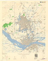
Fu-chou (Foochow) and Nan-t'ai, China, Fukien Province
中國城市規劃 1:12,500 - Creator
- United States. Army Map Service.
- Date Created
- 1945
- Place of Origin
-
Washington, D.C
dcu - Publisher
- U.S. Army Map Service
- Language
- English
- Collection
- East Asian Maps in the Bruman Collection
Notes
- Description
-
Relief represented by contours.
Type C-AMS 1.
prepared under the direction of the Chief of Engineers by the Army Map Service (AM) ... 1945.
"Compiled in 1945 from China 1:50,000 Army Map Service 8833 II (Type C) 1945. Planimetric detail intensified from aerial photography dated 1944-45 by photo-planimetric methods with reference to Fu-chou 1:10,000, General Staff (Fukien Office), 1934."
cp
Includes "Glossary" and notes.
Marginal maps: Coverage diagram -- Index to boundaries.
1st ed.
"Place names were transcribed according to the modified Wade-Giles System."
Military grid.
Some streets and buildings are named; wooded and cultivated areas are shown. - Note
-
easternmost:E1192000
northernmost:N0260800
westernmost:E1191500
southernmost:N0260200
northernmost:N0260700
southernmost:N0260300
Physical Description
- Extent
- 1 map : col. ; 79 x 69 cm.
Keywords
- Genre
- map
- Location
-
Nan-t'ai Shi (Fujian Sheng, China)
12500
Fuzhou (Fujian Sheng, China) - Resource type
- cartographic
- Subjects
-
福州 (福建省, 中國)--地圖
Fuzhou (Fujian Sheng, China)--Maps
Nan-t'ai Shi (Fujian Sheng, China)--Maps
南台市 (福建省, 中國)--地圖
Find This Item
- Repository
- University of California, Los Angeles. Library. Henry J. Bruman Map Collection
- Local Identifier
-
Monograph_Maps
G7824_12.5_AMS_1945_ED1_Fuchou - ARK
- ark:/21198/zz002hdvcf
- Manifest url
-

Access Condition
- Rights statement
- pd_usfed
- Funding Note
- Access to this collection is generously supported by Sammy Yukuan Lee Foundation.