Railways and waterways of Holland
Item Overview
- Title
- Railways and waterways of Holland
- Creator
-
United States. Army Map Service.
Great Britain. War Office. General Staff. Geographical Section. - Date Created
- 1942, 1943 printing
- Date
- 1942
- Place of Origin
-
enk
Washington, D.C
[London] - Publisher
-
Army Map Service, U.S. Army
War Office - Language
- English
- Collection
- Henry J. Bruman Map Collection
Notes
- Description
-
"N5047-E402/239x309."
"5-43."
"War Office, 1942."
"6/42/G.S.G.S."
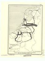
Five classes of railroads with various traffic facilities, and navigable canals and rivers are shown.
Includes inset maps: Continuation west -- Amsterdam -- Rotterdam -- Antwerp.
compiled, drawn, and photolithogaphed at War Office, 1942. - Caption
- 1st ed.-AMS 1.
Physical Description
- Extent
- 1 map : col. ; 99 x 76 cm.
Keywords
- Genre
- map
- Location
-
northernmost:N0532800
westernmost:E0032500
Netherlands
easternmost:E0071400
southernmost:N0504500 - Resource type
- cartographic
- Subjects
-
Waterways--Netherlands--Maps
Nautical charts--Netherlands
Railroads--Netherlands--Maps
Find This Item
- Repository
- University of California, Los Angeles. Library. Henry J. Bruman Map Collection
- ARK
- ark:/21198/zz002cz9pw
- Manifest url
-

Access Condition
- Rights statement
- unknown