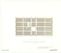
Plan général de Montpazier (Dordogne)
Item Overview
- Title
- Plan général de Montpazier (Dordogne)
- Creator
-
Verneilh, F. de.
Olivier, Théodore, 1793-1853
Didron, Adolphe Napoléon, 1806-1867
Historic Urban Plans (Firm). - Date Created
- 1968
- Date
- 1968
- Place of Origin
-
nyu
Ithaca, N.Y - Publisher
- Historic Urban Plans
- Language
- French
- Collection
- Henry J. Bruman Map Collection
Notes
- Description
-
Library has copy no. 79.
Cadastral map.
dessiné par F. de. Verneilh; gravé par Th. Olivier.
"Montpazier was ... depicted ... in Didron's Annales archéologiques"--Catalog.
Facsim. of: [S.l. : s.n., 1850?].
"Reproduced ... from the original in the Cornell University Library."
Physical Description
- Extent
- 1 map ; 11 x 21 cm. on sheet 29 x 37 cm.
Keywords
- Genre
-
map
fre - Location
- Monpazier (France)
- Resource type
- cartographic
- Subjects
-
Early maps--Facsimiles
Monpazier (France)--Maps--Early works to 1800
Find This Item
- Repository
- University of California, Los Angeles. Library. Henry J. Bruman Map Collection
- ARK
- ark:/21198/zz002cz69r
- Manifest url
-

Access Condition
- Rights statement
- unknown