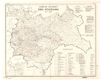
Greater Germany, Kreis boundaries, July 1, 1944
Item Overview
- Title
- Greater Germany, Kreis boundaries, July 1, 1944
- Creator
- United States. Office of Strategic Services. Research and Analysis Branch.
- Date Created
- 1945
- Place of Origin
-
[Washington, D.C.]
dcu - Publisher
- R & A, OSS
- Language
- English
- Collection
- Henry J. Bruman Map Collection
Notes
- Description
-
Includes 2 insets.
"No. 6289 - R & A, OSS, 17 March 1945." - Caption
- Provisional ed.
Physical Description
- Extent
- 1 map ; 59 x 74 cm.
Keywords
- Genre
- map
- Subject Geographic
-
Europe, Central--Administrative and political divisions--Maps
Germany--Administrative and political divisions--Maps - Location
-
Germany
southernmost:N0440000
northernmost:N0550000
westernmost:E0040000
Europe, Central
easternmost:E0280000 - Resource type
- cartographic
Find This Item
- Repository
- University of California, Los Angeles. Library. Henry J. Bruman Map Collection
- ARK
- ark:/21198/zz002cz21p
- Opac url
- https://search.library.ucla.edu/permalink/01UCS_LAL/17p22dp/alma9935142943606533
- Manifest url
-

Access Condition
- Rights statement
-
unknown
public domain