"Greater" Germany caves and cave regions
Item Overview
- Title
- "Greater" Germany caves and cave regions
- Creator
-
United States. Office of Strategic Services. Reproduction Branch.
United States. Office of Strategic Services. Research and Analysis Branch. - Date Created
- 1945
- Date
- 1945-04-25
- Place of Origin
-
[Washington, D.C.]
dcu - Publisher
- OSS
- Language
- English
- Collection
- Henry J. Bruman Map Collection
Notes
- Description
-
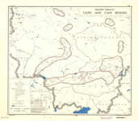
"FREE"--Upper right border and center lower border.
"Small caves not shown."
Shows cave regions within the "Greater" German boundary of 1944.
Includes "Reliability of data" table and notes.
Indexed for cave regions.
lithographed in the Reproduction Branch, OSS.
"No. 6339 -- R & A, OSS, 25 April 1945." - Caption
- Provisional ed.
Physical Description
- Extent
- 1 map : col. ; 50 x 57 cm.
Keywords
- Genre
- map
- Subject Geographic
-
Germany--Maps
Europe, Central--Maps - Location
-
Germany
westernmost:E0060000
northernmost:N0520000
southernmost:N0450000
easternmost:E0180000
Europe, Central - Resource type
- cartographic
- Subjects
-
Caves--Germany--Maps
Caves--Europe, Central--Maps
Find This Item
- Repository
- University of California, Los Angeles. Library. Henry J. Bruman Map Collection
- ARK
- ark:/21198/zz002cz1m0
- Manifest url
-

Access Condition
- Rights statement
- pd_usfed