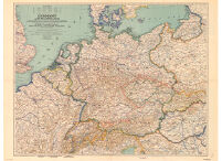
Germany and its Approaches
Item Overview
- Title
- Germany and its Approaches
- Creator
-
National Geographic Society (U.S.). Cartographic Division.
Darley, James M. (James Morrison). - Date Created
- 1944
- Date
- 1944
- Place of Origin
-
Washington
dcu - Publisher
- The Society
- Language
- English
- Collection
- Henry J. Bruman Map Collection
Notes
- Description
-
compiled and drawn in the Cartographic Section of the National Geographic Society. James M. Darley, chief cartographer.
Scale 1:2,000,000; or 31.57 miles to the inch.
"Albers conical equal-area projection: Standard parallels 542̊0 �and 474̊0.�"
Physical Description
- Extent
- col. map ; 63 x 71 cm.
Keywords
- Genre
- map
- Subject Geographic
- Germany--Maps
- Location
- Germany
- Resource type
- cartographic
- Subjects
- Germany--History--1933-1945--Maps
Find This Item
- Repository
- University of California, Los Angeles. Library. Henry J. Bruman Map Collection
- ARK
- ark:/21198/zz002cz0x5
- Manifest url
-

Access Condition
- Rights statement
- unknown