Brittany, roads
Item Overview
- Title
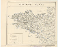
- Brittany, roads
- Creator
- United States. Office of Strategic Services. Research and Analysis Branch.
- Date Created
- 1943
- Date
- 1943
- Place of Origin
-
[Washington, D.C.]
dcu - Publisher
- OSS
- Language
- English
- Collection
- Henry J. Bruman Map Collection
Notes
- Description
-
compiled and drawn in the Branch of Research and Analysis, OSS.
Dated: January 11, 1943.
Relief represented by shading. - Caption
- Provisional ed.
Physical Description
- Extent
- 1 map : col. ; 26 x 33 cm.
Keywords
- Genre
- map
- Subject Geographic
- Brittany (France)--Maps
- Location
-
southernmost:N0470000
northernmost:N0490000
easternmost:W0010000
westernmost:W0050000
Brittany (France) - Resource type
- cartographic
- Subjects
- Brittany (France)--Maps
Find This Item
- Repository
- University of California, Los Angeles. Library. Henry J. Bruman Map Collection
- ARK
- ark:/21198/zz002cfj9v
- Opac url
- https://search.library.ucla.edu/permalink/01UCS_LAL/17p22dp/alma9935142273606533
- Manifest url
-

Access Condition
- Rights statement
- pd_usfed