Ireland (Eire) & Northern Ireland; special strategic map.
Item Overview
- Title
- Ireland (Eire) & Northern Ireland; special strategic map.
- Creator
- United States. Army Map Service.
- Date Created
- 1945
- Date
- 1945
- Place of Origin
-
Washington
dcu - Language
- English
- Collection
- Henry J. Bruman Map Collection
Notes
- Description
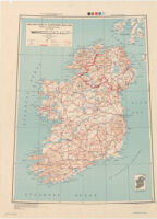
-
Inset shows area with detailed transportation information.
Elevations are shown by contours and spot heights in meters.
"Polyconic projection."
Two classes of roads and three classes of railroads are shown. - Caption
- 1st ed.-AMS 1.
Physical Description
- Extent
- 1 map : col. ; 57 x 44 cm.
Keywords
- Genre
- map
- Subject Geographic
- Ireland--Maps
- Location
- Ireland
- Resource type
- cartographic
- Subjects
- Transportation--Ireland--Maps
Find This Item
- Repository
- University of California, Los Angeles. Library. Henry J. Bruman Map Collection
- ARK
- ark:/21198/zz002cfc8x
- Opac url
- https://search.library.ucla.edu/permalink/01UCS_LAL/17p22dp/alma9933343763606533
- Manifest url
-

Access Condition
- Rights statement
- pd_usfed