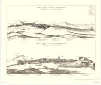
Plan of the new streets and squares intended for the city of Edinburgh
Item Overview
- Title
- Plan of the new streets and squares intended for the city of Edinburgh
- Creator
-
Historic Urban Plans (Firm).
Wit, Frederik de. - Date Created
-
1969
[1695?] - Date
- 1969
- Place of Origin
-
[T' Amsterdam]
ne
Ithaca, N.Y - Publisher
- Historic Urban Plans
- Language
-
English
Latin - Collection
- Henry J. Bruman Map Collection
Notes
- Description
-
"This is number 9 of an edition limited to 500 copies."
Facsimile.
Perspective map not drawn to scale.
Physical Description
- Extent
- 2 maps 20 x 52 cm. on sheet 51 x 59 cm.
Keywords
- Genre
- map
- Subject Geographic
- Edinburgh (Scotland)--Aerial views--Early works to 1800--Facsimiles
- Location
- Edinburgh (Scotland)
- Resource type
- cartographic
- Subjects
- Edinburgh (Scotland)--Aerial views--Early works to 1800--Facsimiles
Find This Item
- Repository
- University of California, Los Angeles. Library. Henry J. Bruman Map Collection
- ARK
- ark:/21198/zz002cfc0s
- Opac url
- https://search.library.ucla.edu/permalink/01UCS_LAL/17p22dp/alma9910491223606533
- Manifest url
-

Access Condition
- Rights statement
- unknown