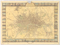
Tallis's illustrated plan of London and its environs
Item Overview
- Title
- Tallis's illustrated plan of London and its environs
- Uniform title
- London and its environs
- Creator
-
John Tallis & Company.
Rapkin, J.
Lacey, H. - Date Created
- [2002?]
- Date
- 2002
- Place of Origin
-
enk
Oxford - Publisher
- Oxford Cartographers Ltd.
- Language
- English
- Collection
- Henry J. Bruman Map Collection
Notes
- Description
-
Relief represented by hachures.
Original version: London : John Tallis & Co., 1851.
Facsimile.
[the map drawn & engraved by J. Rapkin].
Illustrations drawn and engraved by H. Lacey.
"Reproduced by kind permission of the Guildhall Library, City of London, by Cook, Hammond & Kell Ltd."--Lower rt. margin.
Engravings of interesting places around London with names frame map.
Physical Description
- Extent
- 1 map : col. ; 42 x 64 cm.
Keywords
- Genre
- map
- Subject Geographic
- London (England)--Maps
- Location
- London (England)
- Resource type
- cartographic
- Subjects
- London (England)--Maps
Find This Item
- Repository
- University of California, Los Angeles. Library. Henry J. Bruman Map Collection
- ARK
- ark:/21198/zz002cf8dj
- Opac url
- https://search.library.ucla.edu/permalink/01UCS_LAL/17p22dp/alma9948663003606533
- Manifest url
-

Access Condition
- Rights statement
- unknown