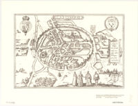
Cantvarbvry
Item Overview
- Title
- Cantvarbvry
- Creator
-
Historic Urban Plans (Firm).
Braun, Georg. 1540 or 1-1622.
Hogenberg, Abraham. fl. 1608-1653. - Date Created
-
1588]
1971 - Place of Origin
-
[Amstelodami?
ne
Ithaca, N.Y - Publisher
- Historic Urban Plans
- Language
- Latin
- Collection
- Henry J. Bruman Map Collection
Notes
- Description
-
"This is number 29 of an edition limited to 500 copies."
From Braun and Hogenberg's Civitates orbis terrarum.
Bird's-eye view.
Facsimile.
"Reproduced ... from an engraving in the collection of Richard A. Smith, Ithaca, New York."
Perspective map not drawn to scale.
Physical Description
- Extent
- map 29 x 43 cm.
Keywords
- Genre
- map
- Subject Geographic
- Canterbury (England)--Aerial views--Early works to 1800--Facsimiles
- Location
- Canterbury (England)
- Resource type
- cartographic
- Subjects
- Canterbury (England)--Aerial views--Early works to 1800--Facsimiles
Find This Item
- Repository
- University of California, Los Angeles. Library. Henry J. Bruman Map Collection
- ARK
- ark:/21198/zz002cf7sr
- Opac url
- https://search.library.ucla.edu/permalink/01UCS_LAL/17p22dp/alma996408903606533
- Manifest url
-

Access Condition
- Rights statement
- unknown