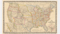
new map of the United States of America
Item Overview
- Title
- new map of the United States of America
- Creator
- Young, J. H. (James Hamilton).
- Date Created
-
1856
[1956] - Date
- 1956
- Place of Origin
-
pau
Philadelphia - Publisher
- Published by Charles Desilver
- Language
- English
- Collection
- Henry J. Bruman Map Collection
Notes
- Description
-
Relief represented by hachures.
Includes insets: Gold region of California and District of Columbia.
by J.H. Young.
"The United States in 1856 as reproduced by Rand McNally & Company to commemorate its one hundredth anniversary in 1956."
Facsimile.
Printed with ornamental border.
Longitude on top of map "West from Greenwich;" on bottom "East/West from Washington."
"Entered according to Act of Congress in the year 1856 by Charles Desilver, in the Clerks office of the District court of the Eastern District of Pennsylvania."
Shows railroad routes proposed to the Pacific Ocean.
Physical Description
- Extent
- 1 map : col. ; 38 x 65 cm.
Keywords
- Genre
- map
- Subject Geographic
- United States--Maps
- Location
- United States
- Resource type
- cartographic
- Subjects
- Railroads--United States--Maps
Find This Item
- Repository
- University of California, Los Angeles. Library. Henry J. Bruman Map Collection
- ARK
- ark:/21198/zz002cf04j
- Opac url
- https://search.library.ucla.edu/permalink/01UCS_LAL/17p22dp/alma9936776893606533
- Manifest url
-

Access Condition
- Rights statement
- unknown