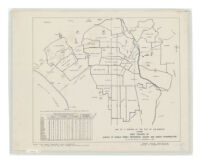
Map of a portion of the City of Los Angeles showing area covered by survey of single family residences vacant and under construction as of the week of November 8, 1937
Item Overview
- Title
- Map of a portion of the City of Los Angeles showing area covered by survey of single family residences vacant and under construction as of the week of November 8, 1937
- Creator
-
Whitlock, Laura L.
United States. Federal Housing Administration. Division of Economics & Statistics. - Date Created
-
[1937?]
1924
c1924
1937 - Place of Origin
-
[Washington, D.C.?]
cau
Los Angeles, Cal - Publisher
-
The Division?
Wolfer Print Co. - Language
- English
- Collection
- Henry J. Bruman Map Collection
Notes
- Description
-
Includes 3 insets.
Federal Housing Administration, Division of Economics & Statistics.
Relief represented by spot heights.
"Official maps."
Includes: "Summary of single family residences vacant and under construction," by postal station district.
Physical Description
- Extent
-
1 map : col. ; 111 x 82 cm.
1 map : photocopy ; 44 x 52 cm.
Keywords
- Genre
- map
- Subject Geographic
- Los Angeles (Calif.)--Maps
- Location
-
Los Angeles (Calif.)
California
Los Angeles - Resource type
- cartographic
- Subjects
-
Housing--California--Los Angeles--Maps
Street-railroads--California--Los Angeles--Maps
Find This Item
- Repository
- University of California, Los Angeles. Library. Henry J. Bruman Map Collection
- ARK
- ark:/21198/zz002c22c6
- Opac url
- https://search.library.ucla.edu/permalink/01UCS_LAL/17p22dp/alma9935044493606533
- Manifest url
-

Access Condition
- Rights statement
- pd_usfed