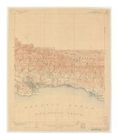
California, Santa Barbara County, Santa Barbara special map
Item Overview
- Title
- California, Santa Barbara County, Santa Barbara special map
- Creator
- Geological Survey (U.S.).
- Date Created
- 1903
- Date
- 1903
- Place of Origin
- [Washington, D.C.]
- Publisher
- U.S. Geological Survey
- Language
- English
- Collection
- Henry J. Bruman Map Collection
Notes
- Description
-
Relief shown by contours and spot heights.
"Triangulation by U.S. Coast and Geodetic Survey ; topography by R.B. Marshall, surveyed in 1902."
Contour interval 50 feet.
Text on verso. - Note
- Ed. of Nov. 1903.
Physical Description
- Extent
- 1 map : col. ; 45 x 37 cm.
Keywords
- Genre
-
map
Topographic maps. - Subject Geographic
- Santa Barbara (Calif.)--Maps
- Location
- Santa Barbara
- Resource type
- cartographic
Find This Item
- Repository
- University of California, Los Angeles. Library. Henry J. Bruman Map Collection
- ARK
- ark:/21198/zz002c20vg
- Opac url
- https://search.library.ucla.edu/permalink/01UCS_LAL/17p22dp/alma9970503243606533
- Manifest url
-

Access Condition
- Rights statement
- pd_usfed