Coleman's Addition to the Town of San Rafael, Marin Co. California. Map Showing Projection of Plan of Improvements
Item Overview
- Title
- Coleman's Addition to the Town of San Rafael, Marin Co. California. Map Showing Projection of Plan of Improvements
- Creator
-
Coleman, William Tell, 1824-1893.
Hall, Wm. Ham. (William Hammond) - Date Created
- [approximately 1880]
- Date
- 1880
- Place of Origin
- [San Francisco, Calif.?]
- Language
- English
- Collection
- Henry J. Bruman Map Collection
Notes
- Description
-
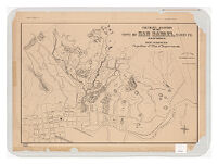
Owners' names include: Chapman, Mrs. Coleman, DeBois, Saunders, Sheppard, Stevens, Irwin, Robert Watt, Wilkins, Winan.
Covers San Rafael and land to the north and east of the city.
Shows roads, buildings, springs, rivers, San Rafael Canal, numbered plots with acreage and owners' names, areas of plantings.
Relief shown by hachures and spot heights.
Physical Description
- Extent
- 1 map
- Dimensions
- 53 x 78 cm
Keywords
- Genre
-
map
Thematic maps. - Subject Geographic
- San Rafael (Calif.) Maps
- Location
- San Rafael (Calif.)
- Resource type
- cartographic
Find This Item
- Repository
- University of California, Los Angeles. Library. Henry J. Bruman Map Collection
- ARK
- ark:/21198/zz002c20sf
- Opac url
- https://search.library.ucla.edu/permalink/01UCS_LAL/trta7g/alma9970502753606533
- Manifest url
-

Access Condition
- Rights statement
- unknown