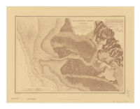
San Antonio Creek, California
Item Overview
- Title
- San Antonio Creek, California
- Creator
- United States Coast Survey.
- Date Created
- [199-?]
- Place of Origin
-
Austin, Tex
txu - Publisher
- Rose Research
- Language
- English
- Collection
- Henry J. Bruman Map Collection
Notes
- Description
-
Relief represented by hachures.
Original version: [Washington, D.C.? : U.S. Coast Survey], 1857.
from a trigonometrical survey under the direction of A.D. Bache, Superintendent of the Survey of the Coast of the United States ; red'd dr'ng by P. Witzel.
Facsimile.
"No. 62."
"Reproduced from the annual reports by permission of United States Coast & Geodetic Survey."
Includes note and table of abbreviations.
Covers portions of cities of Oakland and Alameda, and shows buildings, streets, roads, tidelands, etc.
Physical Description
- Extent
- 1 map ; 33 x 48 cm.
Keywords
- Genre
- map
- Names
-
Rose Research.
Witzel, P. (Peter). - Location
-
westernmost:W1221322
northernmost:N0374727
Oakland
California
southernmost:N0374727
easternmost:W1221322
Alameda - Resource type
- cartographic
- Subjects
-
Nautical charts--California--Oakland
Nautical charts--California--Alameda
Harbors--California--Alameda--Maps
Harbors--California--Oakland--Maps
Find This Item
- Repository
- University of California, Los Angeles. Library. Henry J. Bruman Map Collection
- ARK
- ark:/21198/zz002c1znf
- Opac url
- https://search.library.ucla.edu/permalink/01UCS_LAL/17p22dp/alma9943042453606533
- Manifest url
-

Access Condition
- Rights statement
-
unknown
public domain