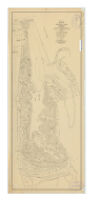
Unrecorded map of Whitley Park : showing existing and proposed subdivision : also golf course, parks & recreational features
Item Overview
- Title
- Unrecorded map of Whitley Park : showing existing and proposed subdivision : also golf course, parks & recreational features
- Uniform title
- Map of Whitley Park
- Creator
- Reaburn & Bowen, Engineers.
- Date Created
- 1929
- Place of Origin
-
[Los Angeles?]
cau - Publisher
- Reaburn & Bowen, Engineers
- Language
- English
- Collection
- Henry J. Bruman Map Collection
Notes
- Description
-
Shows lot numbers, measurements and sizes.
Covers an area from Ventura Blvd. south to Mulholland High Way; with Camino de la Cumbre on the west and Hollyline Ave. and Beverly Glen Road on the east.
"Oct. 1929."
Shows an unnamed golf course in the center of the map; shows the locations of 9 fairways, buildings.
Physical Description
- Extent
- 1 map ; 69 x 27 cm.
Keywords
- Genre
-
map
Cadastral maps. - Subject Geographic
- Sherman Oaks (Los Angeles, Calif.)--Maps
- Location
-
Sherman Oaks (Los Angeles, Calif.)
California
Los Angeles - Resource type
- cartographic
- Subjects
- Real property--California--Los Angeles--Maps
Find This Item
- Repository
- University of California, Los Angeles. Library. Henry J. Bruman Map Collection
- ARK
- ark:/21198/zz002c1x1n
- Opac url
- https://search.library.ucla.edu/permalink/01UCS_LAL/17p22dp/alma9968276943606533
- Manifest url
-

Access Condition
- Rights statement
-
pd_usfed
unknown
public domain