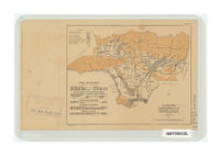
Comprehensive plan, preliminary layout of ultimate development
Item Overview
- Title
- Comprehensive plan, preliminary layout of ultimate development
- Creator
- Los Angeles County Flood Control District.
- Date Created
- 1930
- Place of Origin
-
[Sacramento, Calif]
cau - Publisher
- State of California, Dept. of Public Works, Division of Water Resources
- Language
- English
- Collection
- Henry J. Bruman Map Collection
Notes
- Description
-
Los Angeles County Flood Control District.
"80702--P. 22."
Relief represented by gradient and bathymetric tints.
Map is plate 2 from California Division of Water Resources Bulletin no. 32.
Physical Description
- Extent
- 1 map : col. ; 20 x 25 cm.
Keywords
- Genre
- map
- Location
-
California
Los Angeles County - Resource type
- cartographic
- Subjects
- Flood control--California--Los Angeles County--Maps
Find This Item
- Repository
- University of California, Los Angeles. Library. Henry J. Bruman Map Collection
- ARK
- ark:/21198/zz002c1h8g
- Opac url
- https://search.library.ucla.edu/permalink/01UCS_LAL/17p22dp/alma9922442393606533
- Manifest url
-

Access Condition
- Rights statement
- pd_usfed